 Glacier Park Chat
Is one direction of travel more preferable than the other (northbound v. southbound) when planning a backcountry trip between Two Medicine and St Mary?
Red Eagle Head v. Red Eagle Foot: is one more desirable than the other?
Finally, can you see Katoya Lake from the trail, or does that involve a bushwhack?
Thanks!

Questions re route from Two Medicine to St Mary
-
orin
- Posts: 469
- Joined: Mon May 15, 2006 11:02 pm
- Please add the numbers(11): 0
- Location: Seattle
- Has thanked: 37 times
- Been thanked: 49 times
Re: Questions re route from Two Medicine to St Mary
I've done most of the route in both directions and don't have any particular preference. The ends are both about the same elevation so that isn't an issue. The trail from St Mary to Red Eagle Lake is fairly flat so if you prefered a flat start or a flat finish that might influence your choice. I've only stayed at REH which was OK. No opinion on REH vs REF. Yes, you can see Katoya lake from the trail in various places as you drop down from Pitamakin Pass. No bushwhacking required for the view.
-
MarxMN
- 2.1 Donator

- Posts: 596
- Joined: Wed Aug 30, 2006 9:38 pm
- Gender?: Male
- Please add the numbers(11): 11
- Location: Mazeppa, MN
- Has thanked: 22 times
- Been thanked: 37 times
Re: Questions re route from Two Medicine to St Mary
The 2006 Red Eagle fire burned the through REF campground. I have been through that campground once since the fire - there were no live trees more than eight feet tall. This had previously been a campground in a forested area with nice shade. The sun rises on the mountain across Red Eagle Lake from the REF campground - that is a nice view. I have not been to REH since the Red Eagle fire so I don't know what that campground is like now. As I recall the fire started in the area of REH.
I agree with Orin - the trail from St. Mary to Red Eagle Lake is mostly flat - lots of little ups and downs but nothing major.
I agree with Orin - the trail from St. Mary to Red Eagle Lake is mostly flat - lots of little ups and downs but nothing major.
-
orin
- Posts: 469
- Joined: Mon May 15, 2006 11:02 pm
- Please add the numbers(11): 0
- Location: Seattle
- Has thanked: 37 times
- Been thanked: 49 times
Re: Questions re route from Two Medicine to St Mary
The views of Katoya Lake are actually more restricted than I suggested above. The only place you get a view is between the Katoya outlet and Pitamakin Lake as you climb along the ridge above Katoya. But it is a nice view.

-
wnysteve
- Donator

- Posts: 314
- Joined: Wed Feb 18, 2009 8:22 am
- Gender?: Male
- Please add the numbers(11): 11
- Location: Clarence, NY
Re: Questions re route from Two Medicine to St Mary
I prefer the north to south route. It seemed that by taking the route from Red Eagle Lake up to Triple Divide Pass some of the direct sun was shielded from the trail, whereas the trail to the Pass from the Cut Bank side was totally exposed. Going North-to-South allows you to be going downhill when you reach the open part of that trail.
-
teapot57
- Moderator & 2.1 Donator

- Posts: 944
- Joined: Mon May 20, 2013 3:59 pm
- Gender?: Female
- Please add the numbers(11): 11
- Location: Calgary, AB
- Has thanked: 94 times
- Been thanked: 77 times
Re: Questions re route from Two Medicine to St Mary
Thank you, all! This really helps and you have brought up points I hadn't considered.
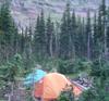
Orin, many thanks for taking the time to upload the photo. It piques my interest and makes me want to venture a bit closer through the trees for a better view of the lake. I wonder if the old trail to the former backcountry campsite still exists, or if there are game trails that make for an easy bushwack to Katoya Lake. Has anyone ever done this?
Orin, many thanks for taking the time to upload the photo. It piques my interest and makes me want to venture a bit closer through the trees for a better view of the lake. I wonder if the old trail to the former backcountry campsite still exists, or if there are game trails that make for an easy bushwack to Katoya Lake. Has anyone ever done this?
-
Fairbanks142
- Donator
- Posts: 194
- Joined: Sun Jan 01, 2012 1:14 pm
- Gender?: Male
- Please add the numbers(11): 11
Re: Questions re route from Two Medicine to St Mary
Did anyone visit Red Eagle Lake in 2018? I'm looking for info on the REF and REH campsites -- how much the forest has come back since the 2006 fire as mentioned in this thread, overall any input on whether the campsite at the foot is better than at the head for overall scenery, access to the lake shore for fishing, or just a better campsite all around? Etc. Thanks all!
-
DawsonPass62
- Posts: 20
- Joined: Mon Jun 18, 2018 1:11 pm
- Gender?: Male
- Please add the numbers(11): 11
- Been thanked: 2 times
Re: Questions re route from Two Medicine to St Mary
I was at REF in August 2018 and walked by REH coming from Triple Divide. The forest is coming back in both areas, but much more at REH. The tent area at REF is still somewhat barren as no large trees have really grown back. I have stayed at both sites in the past, but I prefer REF as you look over the lake and back towards the mountains.
Also, the lake water level at REH is shallow and muddy and not a lot of fun for wading/swimming/fishing, although you would really have to go along the shores to get to some deeper water for fishing. A group was fishing the stream exiting the lake near REF and caught some fish there. You are allowed a fire at both sites, and getting firewood at REF is not a problem. Not sure about REH.
Also, the lake water level at REH is shallow and muddy and not a lot of fun for wading/swimming/fishing, although you would really have to go along the shores to get to some deeper water for fishing. A group was fishing the stream exiting the lake near REF and caught some fish there. You are allowed a fire at both sites, and getting firewood at REF is not a problem. Not sure about REH.
-
Fairbanks142
- Donator
- Posts: 194
- Joined: Sun Jan 01, 2012 1:14 pm
- Gender?: Male
- Please add the numbers(11): 11
-
vikinghiker
- Posts: 9
- Joined: Wed Mar 21, 2018 1:16 pm
- Gender?: Male
- Please add the numbers(11): 11
- Location: MN
Re: Questions re route from Two Medicine to St Mary
We stayed one night at REF in early August 2018 (first ever backcountry night in Glacier!!). The views were great looking toward the head and mountains beyond. Access to the lake was easy, though we didn't fish so I can't speak to that. Campsites were exposed with no shade until the sun started setting behind the mountains. We continued toward Triple Divide the next day and hiked past REH, I agree with the previous post that REH had much more tree growth.
My apologies, but I'm not able to include the image in the post (probably due to my lack of technical ability), but the links below should work.
https://drive.google.com/open?id=1XPTf0 ... vvM0ibESNz - view from the shore at the foot looking toward the head
https://drive.google.com/open?id=1stwMl ... L1gTJoFFnB - view of the campsite at REF
-
Fairbanks142
- Donator
- Posts: 194
- Joined: Sun Jan 01, 2012 1:14 pm
- Gender?: Male
- Please add the numbers(11): 11
Re: Questions re route from Two Medicine to St Mary
Thanks for the info, and yes, the links for the pics work. Like they say, a picture is worth 1000 words!
-
joybird
- Donator
- Posts: 576
- Joined: Sun Jun 24, 2012 9:03 pm
- Gender?: Female
- Please add the numbers(11): 11
- Location: Afton, Virginia
- Has thanked: 4 times
- Been thanked: 1 time
Re: Questions re route from Two Medicine to St Mary
I had a permit for that route in mid-August in 2017 but the fire-related backcountry closures prevented me from being able to do the section up and over Triple Divide Pass. A do-over is on my list for 2019, BC gods willing, so I am also interested in any information people may have. I don't mean to hijack this thread...hopefully these questions will be helpful to Teapot as well!
In particular, I'm curious to know about how early in the season it is practical to hike up from Red Eagle and over Triple Divid Pass? I grew up in Florida and now live in Virginia and am NOT an ice-axe-and-crampons kinda gal. (I have been known to use Yak Trax on occasion, and could be convinced to get microspikes if necessary...)
I am also curious about the "water hazards" that are noted on the maps. Since I'm usually backpacking solo (except when I'm lucky enough to score a fabulous trip with Teapot and Gang! ) I tend to be more conservative about the hazards I'm willing to tackle than I am when I'm with company, so it is important to me to get information about how significant those crossings are. Obviously snowpack and such vary from year to year but does anyone know if they are likely to be problematic, say, in mid-July?
As for Teapot's question about Katoya, when I backpacked the section from MOR to OLD, I kept a cursory eye out for a social trail, but did not see one. I would also be curious if anyone has information about that access. (I hadn't realized there used to be a campground at Katoya...thank you for that tidbit!)
In particular, I'm curious to know about how early in the season it is practical to hike up from Red Eagle and over Triple Divid Pass? I grew up in Florida and now live in Virginia and am NOT an ice-axe-and-crampons kinda gal. (I have been known to use Yak Trax on occasion, and could be convinced to get microspikes if necessary...)
I am also curious about the "water hazards" that are noted on the maps. Since I'm usually backpacking solo (except when I'm lucky enough to score a fabulous trip with Teapot and Gang!
As for Teapot's question about Katoya, when I backpacked the section from MOR to OLD, I kept a cursory eye out for a social trail, but did not see one. I would also be curious if anyone has information about that access. (I hadn't realized there used to be a campground at Katoya...thank you for that tidbit!)
-
orin
- Posts: 469
- Joined: Mon May 15, 2006 11:02 pm
- Please add the numbers(11): 0
- Location: Seattle
- Has thanked: 37 times
- Been thanked: 49 times
Re: Questions re route from Two Medicine to St Mary
I crossed Triple Divide Pass over the July 4 weekend in 2016 or 2017. South to North. There was a little bit of snow just below the pass on the south side. On the north side there was more snow. I had crampons and an ice ax along just in case but I didn't need them. There were a couple of steep spots with snow on them but I was surprised how easy it went. On the north side just as the trail started to level off, there was an unbridged stream crossing that was knee deep and moderately swift. Continuing north there is a supsension bridge just before REH and two more suspension bridges half way between REF and the St Mary trailhead but unless you hate swinging spans they are no problem. The bridges get installed before Memorial Day. Last July 4th weekend I was camping at REF and talked to three guys that had just arrived from Cut Bank. So on low to medium snow years the pass opens earlier than most but it obviously depends on the snowpack.
The hardest part of the trip was the blowdown through the burned areas. I probably went around over or under 100 trees between the north base of the pass and REH. I imagine quite a few go down each year for awhile after the fire so maybe wait until the trail crew goes through.
When I walked past the Katoya outlet, the part I could see looked pretty easy. But I didn't try it.