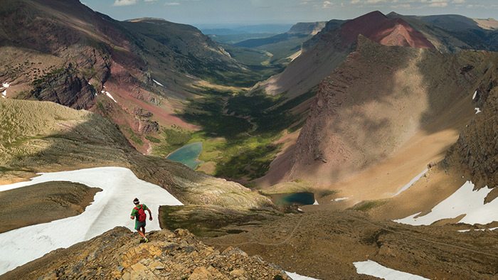
Yeah, that's looking basically NE down Boulder Creek valley/drainage taken from near Siyeh Pass.
After looking at your pic and mine for a while, the pic you posted looks like it was taken somewhere on Matahpi
above the trail but same general line of sight.
ya think?
Siyeh Pass is maybe my all time favorite dayhike. That view is partly why

On a good clear day, it's breathtaking.
There's a natural "rock bench" right at the high point of the hike at ~8000ft.
The trail gets a bit narrow there. Drops off steeply towards that view.
You can sit and eat lunch/snack--and enjoy looking down that drainage.
Convenient since it's also about half way through the hike. Just past that point the trail drops down to that big cairn.
Several times on September hikes, I have seen and heard elk down by the lakes.
I have lots of snapshots of that drainage-- a couple are actually pretty good.
pete
 June 20th 2015 before the Reynolds fire smoked everything up.
There wasn't any wind at all when I took these two pics. Clouds just hung where they were with shadows underneath.
Scary coming down the Baring Creek side that trip. That first snowfield was very steep with a poor run out---a little tense for the geezer.


 Glacier Park Chat