 Glacier Park Chat
Jen, my Pilot fits five!Dang it, Selkie! You are screwing with all my plans! A shuttle makes Akamina actually doable!

Free 2017 Discovery Pass
-
teapot57
- Moderator & 2.1 Donator

- Posts: 944
- Joined: Mon May 20, 2013 3:59 pm
- Gender?: Female
- Please add the numbers(11): 11
- Location: Calgary, AB
- Has thanked: 94 times
- Been thanked: 77 times
Re: Free 2017 Discovery Pass
-
Jen
Re: Free 2017 Discovery Pass
teapot57 wrote:Jen, my Pilot fits five!Dang it, Selkie! You are screwing with all my plans! A shuttle makes Akamina actually doable!
Yer killin' me, Smalls!
-
joybird
- Donator

- Posts: 576
- Joined: Sun Jun 24, 2012 9:03 pm
- Gender?: Female
- Please add the numbers(11): 11
- Location: Afton, Virginia
- Has thanked: 4 times
- Been thanked: 1 time
Re: Free 2017 Discovery Pass
Tina, I'd hike Akamina with you in heartbeat. And if Jen and Maia came along...Jen wrote:teapot57 wrote:
Jen, my Pilot fits five!
Yer killin' me, Smalls!
Jen, if you end up bailing on your backpack permit (or, BC gods forbid, not getting the one you want) and instead do Akamina Ridge, be sure to stay up in Canada for a few days and hike Carthew-Alderson too. A really spectacular hike, that one.
And, if you and Maia are feeling ambitious, you could tackle the Triple Crown Challenge....https://mywaterton.ca/do/challenge-the- ... 50de04b639 I bumped into a couple of people on Carthew-Alderson this past year who were trying to crank it out in three days...which actually seems like something Todd would do (though if it weren't for the ferry and shuttle logistics, he'd probably try to fit it in in two.
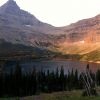
As for me, I'm less interested in the glory of the Triple Crown than in the fun of seeing Boulder Pass from the Canada side. Akamina was such a striking sight from Boulder Pass and Boulder Peak...really pulled at me.
I think we gals need to take a ride in that Pilot!
Hey Selkie! Teapot says there's room for five...(hint, hint).
-
Selkie
- 2.1 Donator

- Posts: 1321
- Joined: Wed Jun 02, 2010 5:17 pm
- Gender?: Female
- Please add the numbers(11): 11
- Location: Chicago
- Has thanked: 41 times
- Been thanked: 9 times
Re: Free 2017 Discovery Pass
It's been a long time since those dancing green bobbleheads made their appearance on the Chat. 
I have enough difficulties coordinating my schedule with myself!
Jen, it will feel great to move beyond the Glacier permit mess. The Bob welcomes you with open arms. Even O Canada has some pretty decent places for a backpack.

I have enough difficulties coordinating my schedule with myself!
Jen, it will feel great to move beyond the Glacier permit mess. The Bob welcomes you with open arms. Even O Canada has some pretty decent places for a backpack.
-
Jen
Re: Free 2017 Discovery Pass
Turning this into a PM.....joybird wrote:Tina, I'd hike Akamina with you in heartbeat. And if Jen and Maia came along...Jen wrote:teapot57 wrote:
Jen, my Pilot fits five!
Yer killin' me, Smalls!
Jen, if you end up bailing on your backpack permit (or, BC gods forbid, not getting the one you want) and instead do Akamina Ridge, be sure to stay up in Canada for a few days and hike Carthew-Alderson too. A really spectacular hike, that one.
And, if you and Maia are feeling ambitious, you could tackle the Triple Crown Challenge....https://mywaterton.ca/do/challenge-the- ... 50de04b639 I bumped into a couple of people on Carthew-Alderson this past year who were trying to crank it out in three days...which actually seems like something Todd would do (though if it weren't for the ferry and shuttle logistics, he'd probably try to fit it in in two.).
As for me, I'm less interested in the glory of the Triple Crown than in the fun of seeing Boulder Pass from the Canada side. Akamina was such a striking sight from Boulder Pass and Boulder Peak...really pulled at me.
I think we gals need to take a ride in that Pilot!
Hey Selkie! Teapot says there's room for five...(hint, hint).
-
akamina3
- Posts: 30
- Joined: Sun Jul 29, 2012 5:32 pm
- Gender?: Male
- Please add the numbers(11): 11
- Location: Pincher Creek, Alberta
Re: Free 2017 Discovery Pass
We snowshoed up to Cameron Lake a few times this winter. I fully expect to be able to drive to the Akamina parking lot this summer. We will certainly hike Akamina Ridge again this summer.
Tip: be sure to hike it from Forum Lake up Akamina Ridge down to Wall Lake and out.
Tip: be sure to hike it from Forum Lake up Akamina Ridge down to Wall Lake and out.
-
Jen
Re: Free 2017 Discovery Pass
Thanks! I am really trying to fit this into the plan!akamina3 wrote: We will certainly hike Akamina Ridge again this summer.
Tip: be sure to hike it from Forum Lake up Akamina Ridge down to Wall Lake and out.
-
joybird
- Donator
- Posts: 576
- Joined: Sun Jun 24, 2012 9:03 pm
- Gender?: Female
- Please add the numbers(11): 11
- Location: Afton, Virginia
- Has thanked: 4 times
- Been thanked: 1 time
Re: Free 2017 Discovery Pass
Akamina or Teapot or others who are familiar with the Canada parks:
What map do you recommend for these Canada parks? My National Geographic map is my go-to map traveling in Glacier, but it doesn't even have the Akamina Ridge trail showing on it. Makes me suspect there are probably other gems up in the Waterton area that may be missing from my map as well...
Also, have you done any backpacking up there? What has your experience been of the BC permit process?
-
akamina3
- Posts: 30
- Joined: Sun Jul 29, 2012 5:32 pm
- Gender?: Male
- Please add the numbers(11): 11
- Location: Pincher Creek, Alberta
Re: Free 2017 Discovery Pass
Good morning.
Sigh... I have too many maps for too many areas.
For what areas are you interested?
Trevor
Sigh... I have too many maps for too many areas.
For what areas are you interested?
Trevor
-
akamina3
- Posts: 30
- Joined: Sun Jul 29, 2012 5:32 pm
- Gender?: Male
- Please add the numbers(11): 11
- Location: Pincher Creek, Alberta
Re: Free 2017 Discovery Pass
My favourite go-to map for Waterton (including Akamina Ridge) is titled Waterton Lakes National Park 3rd edition. It is published by Gem Trek Publishing. FYI, it uses an odd mixture of feet and/or meters for elevation, and km and/or miles for distance.
-
teapot57
- Moderator & 2.1 Donator
- Posts: 944
- Joined: Mon May 20, 2013 3:59 pm
- Gender?: Female
- Please add the numbers(11): 11
- Location: Calgary, AB
- Has thanked: 94 times
- Been thanked: 77 times
Re: Free 2017 Discovery Pass
akamina3 wrote:My favourite go-to map for Waterton (including Akamina Ridge) is titled Waterton Lakes National Park 3rd edition. It is published by Gem Trek Publishing. FYI, it uses an odd mixture of feet and/or meters for elevation, and km and/or miles for distance.
I have this same map. It also shows portions of the northern half of Glacier Park, which I find useful.
I was in Waterton this weekend. Will post a trip report soon.
-
joybird
- Donator
- Posts: 576
- Joined: Sun Jun 24, 2012 9:03 pm
- Gender?: Female
- Please add the numbers(11): 11
- Location: Afton, Virginia
- Has thanked: 4 times
- Been thanked: 1 time
Re: Free 2017 Discovery Pass
Thanks for the map recommendations. I will order one.
Looking forward to your trip report, Tina!
Still would love to hear if anyone has done any backpacking there and what their experience of the BC permit process is....
Looking forward to your trip report, Tina!
Still would love to hear if anyone has done any backpacking there and what their experience of the BC permit process is....
-
akamina3
- Posts: 30
- Joined: Sun Jul 29, 2012 5:32 pm
- Gender?: Male
- Please add the numbers(11): 11
- Location: Pincher Creek, Alberta
Re: Free 2017 Discovery Pass
Good afternoon, joybird:
Please forgive my confusion about where you are interesting in backpacking...
There are a few backcountry campsites in Waterton, but there are no backcountry trips because the park is too small. I have done every hike in Waterton as a day hike. If you are interested in backcountry camping, you get your permit through the visitor centre.
We live about 25 miles north of Waterton, and 35 miles north of Glacier. We hike in Waterton and Glacier, and backpack in Glacier.
I have spent a lot of time over the provincial boundary into British Columbia -- both in the Akamina-Kishinea Provincial Park and beyond. Few people venture west of Wall Lake. If you want to backpack in the park, you can register and pay a small fee new the turnoff to Wall Lake, or you can register at home and print out your permit.
Although you will be hiking along a pre-Depression era forestry road, it is wild. This valley has the densest concentration of grizzly bears in British Columbia. It is remote. It is wild.
If you head west of the provincial park, you will enter BC forestry. There, you can random camp. You will come very close to the Kintla, but you cannot legally cross the Canada-USA border. There used to be a border crossing close to Polebridge, which made for an interesting loop, but I think it closed during the floods of 1995. Perhaps it will reopen one day if/when Waterton is extended to the Flathead river. Perhaps one day...
Please feel free to let me know if you want more information.
-
llholmes1948
- Donator
- Posts: 5222
- Joined: Sun May 20, 2007 8:48 pm
- Please add the numbers(11): 0
- Location: Maine
- Has thanked: 37 times
- Been thanked: 47 times
Re: Free 2017 Discovery Pass
Trevor,akamina3 wrote:Good morning.
Sigh... I have too many maps for too many areas.
For what areas are you interested?
Trevor
Scientists have determined that it is not possible to have too many maps
Lyman
-
PeteE
- Posts: 3346
- Joined: Tue Apr 08, 2014 12:20 pm
- Gender?: Male
- Please add the numbers(11): 11
- Location: Winter hHaven Florida
- Has thanked: 3 times
- Been thanked: 1 time
- Contact:
Re: Free 2017 Discovery Pass
I looked for that map and found only two places. Not in Stock 
So if someone finds a source, please post it.
pete
So if someone finds a source, please post it.
Sounds like my kind of hiking.Although you will be hiking along a pre-Depression era forrestry road, it is wild. This valley has the densest concentration of grizzly bears in British Columbia. It is remote. It is wild.
pete
"If you are not curious, you will learn nothing" -Goethe-
"When you're born in this world, you're given a ticket to the freak show.
And when you're born in America, you're given a front row seat."
George Carlin
"When you're born in this world, you're given a ticket to the freak show.
And when you're born in America, you're given a front row seat."
George Carlin