 Glacier Park Chat
Thanks Missy!

Wind River Backpack TR
-
paul

- Donator

- Posts: 1705
- Joined: Tue Oct 10, 2006 7:42 pm
- Gender?: Male
- Please add the numbers(11): 11
- Location: MA
- Has thanked: 66 times
- Been thanked: 46 times
Re: Wind River Backpack TR
August 12 - Day 5
My plan on this day was to make it a short mileage day and only hike to Washakie lake or Macron lake. Before my hike I took some pictures and video.

Short video of the area around my camp
https://photos.google.com/share/AF1QipP ... pxTUxnTkhR
After breakfast I headed out. My camp was about a quarter mile from the trail junction to the Washakie pass trail. At the trail junction you either turn left/east and cross the river to head toward Valentine lake or turn right toward Washaskie pass. My original route was to go toward the east, but today I headed west which would bring me back on to the trail which I originally started.
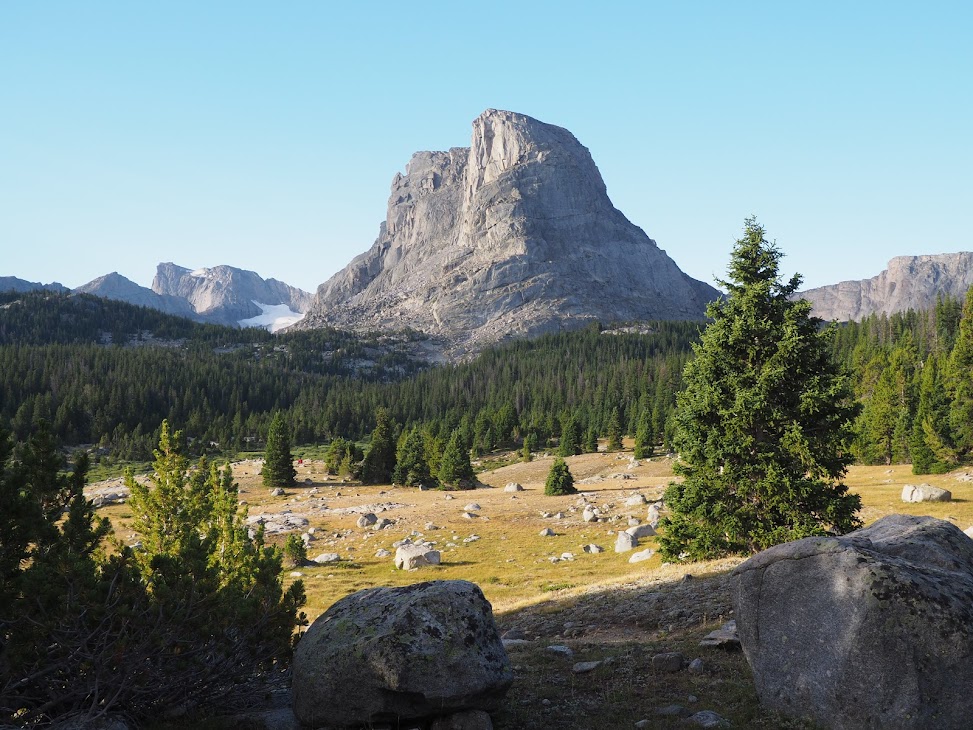
So I headed up the Washakie pass trail thinking I would camp at Washakie or Macron lake. It was my understanding that there was about 300ft of elevation gain to a series of lakes leading up to getting to Washakie lake and then there's a climb of about 400ft to Macron lake. So I quickly hit the first up hill section and found the first lakes. At this point I didn't think it was Washakie lake already because it didn't take me long enough to get there so I kept on hiking. I hit more hills and then arrived at another lake. Unfortunately this lake was not very hospitable for camping. It was quite exposed with the trees being small it didn't look like there was good spots to setup camp. The weather was deteriorating too. I then realized that I had hiked by Washakie lake and was now at Macron lake. Ugh!
So I had two choices:
1) hike back down the trail to Washakie lake.
2) Continue hiking up to Washakie pass and then back down to suitable camping well below the pass.
Well seeing that it was about noon and I didn't want to lose the precious elevation that I gained getting to this point. I decided to have a some lunch and then push over the pass. This was not my plan but it seemed like the best choice for me a the time.
The trail and pass seemed rather daunting. I spoke with a group of hikers who coming down from the pass and they said the trail was extremely steep!
So after having something to eat I started on my way up. I was at 10,700ft and the pass was another 1000ft on the steep trail. This would be the highest backpacking elevation ever. I decided to take my time and stop whenever I felt winded. I knew it would slow going but each step got me a little closer to the top.
On I went hiking some, then stopping, catching my breath, then hiking some more. It was gut check for me as the winds blowing directly at me as I hiked upward. But I plugged on and finally made it to the top.

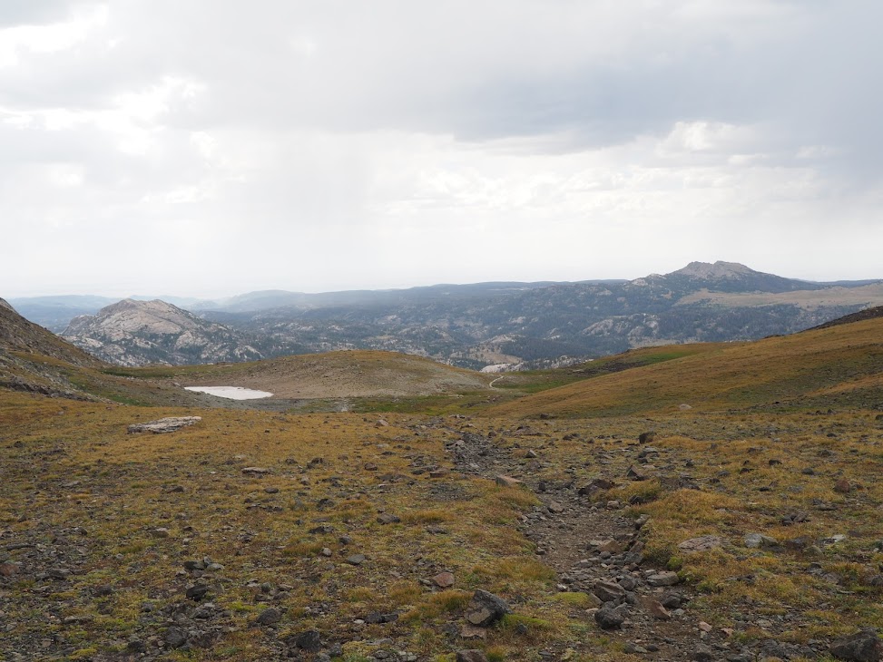
The best view was to the east but a group of day hikers from Washakie Lake were in the spot I should have been to take a good photo. You can see Macron lake on the left and Washakie lake on right. It looks like both are level with each other but Washakie Lake is 400 feet below Macron Lake.

Looking west from the pass. I was a much more gradual descent. It doesn't look like much but there was nice scenery coming the other side.
The weather at the pass was not looking good so I tucked away my camera again and quickly got on my way! Not far down from the pass the weather got really bad with hail and cold rain blowing right at me. I had my rain jacket on but I was wearing shorts on my legs. My shorts got soaked quickly and I upped my pace to get down as fast as I could. I was getting pretty cold when it stopped storming. I kept a quick pass because the skies were still threatening more rain and hail.
By the time I reached the Pyramid lake trail junction it was warmer and my shorts were dry again. Now it was time to figure out where I would camp for the night. Skull lake is about a mile from the trail junction but I would have to go in the wrong direction to get there. I originally thought that I would camp at Skull lake but since it was only 4pm I figured I could get in a couple more miles and make my hike out the next day easier. So I decided to hike the 2 miles to make camp at Marm's lake (this is where I had camped the first 2 nights).
I was beat by the time I got to Marm's Lake. I setup camp in the same spot as my first camp. I so tired that I didn't feel like cooking a hot meal, so I just has some of cold stuff and rested while the sun went down.
My plan on this day was to make it a short mileage day and only hike to Washakie lake or Macron lake. Before my hike I took some pictures and video.
Short video of the area around my camp
https://photos.google.com/share/AF1QipP ... pxTUxnTkhR
After breakfast I headed out. My camp was about a quarter mile from the trail junction to the Washakie pass trail. At the trail junction you either turn left/east and cross the river to head toward Valentine lake or turn right toward Washaskie pass. My original route was to go toward the east, but today I headed west which would bring me back on to the trail which I originally started.
So I headed up the Washakie pass trail thinking I would camp at Washakie or Macron lake. It was my understanding that there was about 300ft of elevation gain to a series of lakes leading up to getting to Washakie lake and then there's a climb of about 400ft to Macron lake. So I quickly hit the first up hill section and found the first lakes. At this point I didn't think it was Washakie lake already because it didn't take me long enough to get there so I kept on hiking. I hit more hills and then arrived at another lake. Unfortunately this lake was not very hospitable for camping. It was quite exposed with the trees being small it didn't look like there was good spots to setup camp. The weather was deteriorating too. I then realized that I had hiked by Washakie lake and was now at Macron lake. Ugh!
So I had two choices:
1) hike back down the trail to Washakie lake.
2) Continue hiking up to Washakie pass and then back down to suitable camping well below the pass.
Well seeing that it was about noon and I didn't want to lose the precious elevation that I gained getting to this point. I decided to have a some lunch and then push over the pass. This was not my plan but it seemed like the best choice for me a the time.
The trail and pass seemed rather daunting. I spoke with a group of hikers who coming down from the pass and they said the trail was extremely steep!
So after having something to eat I started on my way up. I was at 10,700ft and the pass was another 1000ft on the steep trail. This would be the highest backpacking elevation ever. I decided to take my time and stop whenever I felt winded. I knew it would slow going but each step got me a little closer to the top.
On I went hiking some, then stopping, catching my breath, then hiking some more. It was gut check for me as the winds blowing directly at me as I hiked upward. But I plugged on and finally made it to the top.
The best view was to the east but a group of day hikers from Washakie Lake were in the spot I should have been to take a good photo. You can see Macron lake on the left and Washakie lake on right. It looks like both are level with each other but Washakie Lake is 400 feet below Macron Lake.
Looking west from the pass. I was a much more gradual descent. It doesn't look like much but there was nice scenery coming the other side.
The weather at the pass was not looking good so I tucked away my camera again and quickly got on my way! Not far down from the pass the weather got really bad with hail and cold rain blowing right at me. I had my rain jacket on but I was wearing shorts on my legs. My shorts got soaked quickly and I upped my pace to get down as fast as I could. I was getting pretty cold when it stopped storming. I kept a quick pass because the skies were still threatening more rain and hail.
By the time I reached the Pyramid lake trail junction it was warmer and my shorts were dry again. Now it was time to figure out where I would camp for the night. Skull lake is about a mile from the trail junction but I would have to go in the wrong direction to get there. I originally thought that I would camp at Skull lake but since it was only 4pm I figured I could get in a couple more miles and make my hike out the next day easier. So I decided to hike the 2 miles to make camp at Marm's lake (this is where I had camped the first 2 nights).
I was beat by the time I got to Marm's Lake. I setup camp in the same spot as my first camp. I so tired that I didn't feel like cooking a hot meal, so I just has some of cold stuff and rested while the sun went down.
We are in the mountains and the mountains are in us. - John Muir
-
paul
- Donator
- Posts: 1705
- Joined: Tue Oct 10, 2006 7:42 pm
- Gender?: Male
- Please add the numbers(11): 11
- Location: MA
- Has thanked: 66 times
- Been thanked: 46 times
Re: Wind River Backpack TR
Day 6 - last day
Not much to say about this day, it was a hike out to the car day. About 7 miles in total, much of it down hill or on a flat terrain. I was looking forward to getting to my car and then getting a hot meal and a beer or two.
I left camp around 10 am which was pretty late. I had a few equipment snafus which delayed me from getting going earlier. One of the most annoying ones was my water filter not working properly which was happening the entire trip. On my next trip I'm going to bring iodine tablets as backup.
I got to my car about 1pm. It's always a good feeling to find your car there where you left it and in good condition. I always worry that someone's going to break in, steal something or do some damage. Especially when you leave a vehicle for a week in a place where stuff like that could happen.
My trip review
Here are my general impressions of the Wind River Range as far as Hiking goes. Note that I only went to one part of the range and it could be very different in other parts of it.
The Good
- Getting a chance to see new scenery. I've been going to Glacier NP so many years that I forgot the feeling you get when hiking a new trail with great scenery.
- Not having to get permit to go backpacking. I agree with the national park service BC permitting policies but it was nice to be able to create an itinerary based on what I wanted to do and when I wanted to do it and not be restricted. There was so much more flexibility to my schedule I didn't have to camp in certain places and I could change things on fly based on how I felt and on the weather.
- Generally speaking the days were nice and sunny. In July and August the general weather is good except for very consistent thunderstorms in the afternoon. The afternoon storms are something you can prepare for though.
- Bugs were not bad, at least the mosquitoes were pretty tame where I was. I never used bug spray. The one problem I had was with little tiny black flies which crawl on your legs an leave nasty welts when they bite. This was only an issue east of the divide for some reason. These flies are not the same has the black flies in glacier. Those flies are bigger and their bites hurt more.
- The trails were pretty empty of people after you get far enough away from the trail head. I only saw a few people when I was hiking the passes. Closer to the trailhead you do see more people and they can be kind of obnoxious with their dogs and lack of camping and trail etiquette.
The Bad
- I saw very little wildlife. Not sure if that was normal or not. I didn't see anything larger than a marmot. There was no evidence of bears, I did see some elk or deer skulls in one place. Outside of hiking I had some decent sightings while driving. I saw some antelope and a bull moose. And not far from the trailhead I spotted a wolf crossing the road in front of me. I'm not sure why I didn't anything while backpacking maybe the larger animals are scared away by dogs on the trail or the outfitters with their horses and dogs.
- Not a big fan of dogs on the trail. I just don't think it is a good practice in a wilderness area like this. Although most people were pretty good with keeping their dogs under control.
- Also not a big fan of the horse outfitters. I know they serve a purpose and they helped create the trail system but it's kind of annoying when you are completely exhausted on a mountain trail and you have to pull yourself and your pack out of the way on a steep slope barely keeping you're footing while doing so. This happened to me many times. Oh, and the horse droppings on the trail are not very pleasant either. By the way, the dogs with outfitters were the most annoying, they would be barking the whole time and running all over the place.
The Ugly
- Big Sandy trailhead parking was a complete mess. When cars are parked a mile from the trailhead you know you have an issue. I was almost was not able to get through because there were so many cars parked illegally on the dirt road, making passing through very difficult. What if an emergency vehicle needed to get through. The whole thing was a big mess.
- My take is that parts of the southern Winds are over used and over run by too many people. I didn't make it out there but my guess by the number of people hiking out on the trail is that Big Sandy lake is filled daily with tents all over the place. Word has it that there is also a bear problem there because of the total number of campers many of which don't follow good practices with food.
- I saw quite a cases of people not practicing good camping/leave no trace etiquette. Many people camp way too close to water sources and their tents are very visible to people on the trail and other camp sites. There are usually plenty of suitable camp sites available that you don't have to camp in sight of the trail or too close to lakes or rivers. Also, I can't believe people were building camp fires when the entire area was on high fire alert. That was crazy!
We are in the mountains and the mountains are in us. - John Muir
-
McKee80
- Donator
- Posts: 129
- Joined: Thu Feb 09, 2017 5:30 pm
- Gender?: Male
- Please add the numbers(11): 11
Re: Wind River Backpack TR
Sounds like a great trip to a new area. I still hope to get out there at some point! Thanks for the report
-
TnTammy
- Donator
- Posts: 388
- Joined: Sat Sep 24, 2011 5:44 pm
- Gender?: Female
- Please add the numbers(11): 11
- Location: Nashville, TN
Re: Wind River Backpack TR
Thanks for this trip report Paul!
Congrats on venturing out to someplace new that was so breathtaking.
Appreciate you sharing not only the trail but also your experience with the altitude and 'the crowds'.
Mike and i have thought of The Winds for a long time. He took a brief trip there years ago with a scout troop, starting at Big Sandy, where several members really struggled with altitude issues.
It was encouraging to hear that your solitude improved significantly once you got 2 or more days in.
Again, thanks for your great descriptions and photos....the place looks spectacular!
-
paul
- Donator
- Posts: 1705
- Joined: Tue Oct 10, 2006 7:42 pm
- Gender?: Male
- Please add the numbers(11): 11
- Location: MA
- Has thanked: 66 times
- Been thanked: 46 times
Re: Wind River Backpack TR
Thanks Tammy,TnTammy wrote: ↑Fri Oct 16, 2020 6:21 am Thanks for this trip report Paul!
Congrats on venturing out to someplace new that was so breathtaking.
Appreciate you sharing not only the trail but also your experience with the altitude and 'the crowds'.
Mike and i have thought of The Winds for a long time. He took a brief trip there years ago with a scout troop, starting at Big Sandy, where several members really struggled with altitude issues.
It was encouraging to hear that your solitude improved significantly once you got 2 or more days in.
Again, thanks for your great descriptions and photos....the place looks spectacular!
As far a crowds go, the only time where I experienced too many people was on the trail leading to Big Sandy Lake. I thought by the time I got to Marms lake, it was pretty moderate. The higher passes and altitude areas seem to be pretty vacant of people.
I recommend that you visit the Winds, just be prepared more for the altitude than I was.
Paul
We are in the mountains and the mountains are in us. - John Muir
-
paul
- Donator
- Posts: 1705
- Joined: Tue Oct 10, 2006 7:42 pm
- Gender?: Male
- Please add the numbers(11): 11
- Location: MA
- Has thanked: 66 times
- Been thanked: 46 times
Re: Wind River Backpack TR
Thanks, I think you'd like it there. It's definitely more Challenging than Glacier but it's worth it.
We are in the mountains and the mountains are in us. - John Muir