 Glacier Park Chat
Can anyone describe the day-hike from the Granite Park Chalet to Ahern pass (and Iceberg lake overlook/"notch") and back? Most of what I have found refers to it as part of the Fifty Mountain to Granite Park hike. I am interested in knowing distance and elevation gain and scenery.
Thanks,
David

Ahern pass
-
sj in cal
- Posts: 943
- Joined: Thu Jan 26, 2006 7:50 pm
- Gender?: Male
- Please add the numbers(11): 11
- Location: Benicia, California
Re: Ahern pass
It's relatively easy, flat, and about 4.5 miles to the Ahern Pass trail, one way. I've got photos at home, I'm sure someone can post a few. Check out Ahern Pass on Google Earth. The Notch is +1000 ft scramble up from the pass.
-
old_hiker
- Posts: 167
- Joined: Sun Mar 26, 2006 10:58 am
- Please add the numbers(11): 0
- Location: Lethbridge Alberta
Re: Ahern pass
Yes its usually done by people on the Granite-50 Mntn trip.
Your elevation gain is very little until at the cut-off. Views are spectacular, Hidden Lake & you can see Elizebeth L in the distance.Best view of all is up at the top of Iceberg notch looking directly down onto Iceberg.
Sat up there having a snack one day & heard 2 guys,they had come up Iceberg notch & where looking for the goat trail over to Ptarmigan tunnel.
John
-
llholmes1948
- Donator

- Posts: 5224
- Joined: Sun May 20, 2007 8:48 pm
- Please add the numbers(11): 0
- Location: Maine
- Has thanked: 37 times
- Been thanked: 47 times
Re: Ahern pass
Is the spur trail from the Northern Highline trail to Ahern Pass an official trail maintained by the Park? Ruhle's 1949 Guidebook and his 1972 Guidebook certainly give the impression that it is an official trail and he gives it a trail number (125). I don't know what its current status is and Molvar's hiking guide seems a bit vague on this. Is it actually a trail that can be easily followed or does it involve some bushwacking or cross country travel?
Do I understand correctly that there is a sign at the jct. of the spur trail?
Perhaps someone can tell me about Ahern Drift as well. It always seems to get prominent mention in the trail status reports and seems to be a major obstacle on the northern highline. My impression is that it is located between the Ahern Pass trail junction and Granite Park Chalet so that one has to cross the drift in order to reach the Ahern Pass trail.
Ruhle has a photo of the snowdrift in his 1972 Guidebook (page 100). It looks like it is a very high angle drift but the photo doesn't show what is at the bottom so if you took a slide on this drift, I can't tell if you would crash into rocks at the bottom or go flying off a cliff.
Thanks,
Lyman
-
Ear Mountain

- Moderator & 2.1 Donator

- Posts: 4981
- Joined: Fri Jun 22, 2007 9:53 pm
- Gender?: Male
- Please add the numbers(11): 11
- Location: Choteau, Montana
- Has thanked: 37 times
- Been thanked: 41 times
- Contact:
Re: Ahern pass
Take a look at the Ahern Pass 7 1/2 minute USGS quadrangle (every Glacier fanatic should have a complete set of these maps as they provide much more detail than the whole park maps). About a mile south of Ahern Pass the Highline trail to Granite Park ascends along the side of a cliff. That cliff is on the NE side of a spur off the Continental Divide. A big snow drift completely covers the trail there every winter. That drift lasts well into the summer. In some years the Highline trail is closed until almost August because of the danger posed by that drift. One summer in the 1990s I was able to easily get BC permits for 3 consecutive nights at Fifty Mountain because the Ahern Drift was preventing many from doing that route. To reach Fifty I had yo go over Flattop Mountain. That year the Park Service finally sent a crew to blast the drift sometime around the first of August.
In more recent years the Ahern Drift has not been a problem because of the warm springs and dry winters we've been having. But this year is another story and the Ahern Drift might be a little more spectacular and a little more difficult to cross early in the summer.
In more recent years the Ahern Drift has not been a problem because of the warm springs and dry winters we've been having. But this year is another story and the Ahern Drift might be a little more spectacular and a little more difficult to cross early in the summer.
Text and photos Copyright 2007-2023.
-
sj in cal
- Posts: 943
- Joined: Thu Jan 26, 2006 7:50 pm
- Gender?: Male
- Please add the numbers(11): 11
- Location: Benicia, California
Re: Ahern pass
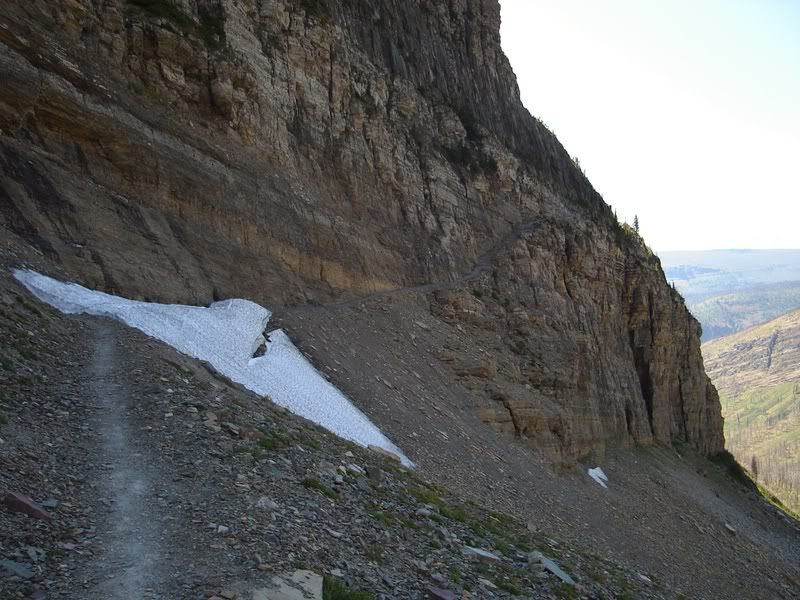
Yes, there is a trail sign...and a large stream, you can't miss. It's an easy walk up to the pass. The photo is the Ahern Drift from 1st week in August 2006 (looking south). The same time in 2007, it was gone. I can post some photos of Ahern Pass if you like, but I'm sure others with more skills have better photos.
-
Ear Mountain
- Moderator & 2.1 Donator
- Posts: 4981
- Joined: Fri Jun 22, 2007 9:53 pm
- Gender?: Male
- Please add the numbers(11): 11
- Location: Choteau, Montana
- Has thanked: 37 times
- Been thanked: 41 times
- Contact:
Re: Ahern pass
Lyman,
Looking at sj in cal's photo of the Ahern drift you can see the problem. His photo was taken the 1st week in August 2006 which was a relatively low snow year and a warm summer. In heavy snow years and earlier in the season the snow extends onto the trail where it goes through the cliff face. When the snow is covering that part of the trail the trail is usually kept closed due to the dangerous crossing. I remember years when the trail was still closed in early August.
In any case the closure would be posted near the chalet and most likely at Fifty Mountain.
Text and photos Copyright 2007-2023.
-
llholmes1948
- Donator
- Posts: 5224
- Joined: Sun May 20, 2007 8:48 pm
- Please add the numbers(11): 0
- Location: Maine
- Has thanked: 37 times
- Been thanked: 47 times
Re: Ahern pass
SJ and Ralph,
Thanks for your photo and further information. The photo in Ruhle's 1972 Guidebook shows this snowdrift as being considerably larger than in SJ's photo. I recall seeing mention from time to time in the trail status reports that the drift was scheduled to be blasted.
Ruhle's 1949 Guidebook indicates that the trail between Granite Park and Fifty Mountain was opened in 1929. Previously Fifty Mountain had to be accessed on the trail via Flattop Mt.
Lyman
-
Ear Mountain
- Moderator & 2.1 Donator
- Posts: 4981
- Joined: Fri Jun 22, 2007 9:53 pm
- Gender?: Male
- Please add the numbers(11): 11
- Location: Choteau, Montana
- Has thanked: 37 times
- Been thanked: 41 times
- Contact:
Re: Ahern pass
There was another way as well. That was the McDonald Creek trail. This started at Packers Roost and went coincidentally with the Flattop Mountain to the crossing of Mineral Creek. Just aobve that stream crossing. The McDonald Creek trail paralleled the stream eventually following Trapper Creek for a while. Then, after ascending some switchbacks the trail passed the headwaters of McDonald Creek and turned NE, went over the summit of West Flattop Mountain, descended to Kootenai Pass and ascended the upper reaches of Kootenai Creek to Fifty Mountain. This trail was abandoned shortly after the 1964 flood but could still be followed into the late 1970s. Nowadays it is almost completely obliterated except for the random disk on a tree and a few areas where wildlife are maintaining the trail tread.Lyman wrote:Ruhle's 1949 Guidebook indicates that the trail between Granite Park and Fifty Mountain was opened in 1929. Previously Fifty Mountain had to be accessed on the trail via Flattop Mt.
Text and photos Copyright 2007-2023.
-
llholmes1948
- Donator
- Posts: 5224
- Joined: Sun May 20, 2007 8:48 pm
- Please add the numbers(11): 0
- Location: Maine
- Has thanked: 37 times
- Been thanked: 47 times
Re: Ahern pass
Since I don't have a great understanding of these trails perhaps I misunderstood Ruhle's remarks. This is what he stated in his 1949 Guidebook at page 70:Ear Mountain wrote:There was another way as well. That was the McDonald Creek trail. This started at Packers Roost and went coincidentally with the Flattop Mountain to the crossing of Mineral Creek. Just aobve that stream crossing. The McDonald Creek trail paralleled the stream eventually following Trapper Creek for a while. Then, after ascending some switchbacks the trail passed the headwaters of McDonald Creek and turned NE, went over the summit of West Flattop Mountain, descended to Kootenai Pass and ascended the upper reaches of Kootenai Creek to Fifty Mountain. This trail was abandoned shortly after the 1964 flood but could still be followed into the late 1970s. Nowadays it is almost completely obliterated except for the random disk on a tree and a few areas where wildlife are maintaining the trail tread.
"It was opened to travel in 1929, before that time, it was necessary to make the arduous trip down to Mineral Creek on trail 62, a drop of 2800 feet, and the long trek (trail 128) up that stream to the top of Flattop Mt. (6800)."
Either Ruhle made an error or the trail numbers were later changed as Ruhle's 1972 Guidebook shows trail 62 as the Loop Trail.
In Ruhle's 1972 Guidebook, his map of the area on page 82 shows trail 63 heading west from Packers Roost. At Mineral Creek, the trail divides with one trail appearing to go Northwest and the other appearing to go west. Unfortunately these trails run off the map pretty quick but the trail running west must be the now abandoned trail that you mention and the trail running northwest must be the existing trail which I guess is called the Mineral Creek trail.
I think Balou posted some wonderful scans from some early trail maps a while back and I will have to see if the link is still on the Chat and if this abandoned trail is shown on the map.
Thanks,
Lyman
-
lcrans

- Posts: 535
- Joined: Thu Jan 31, 2008 6:39 pm
- Please add the numbers(11): 0
- Location: Bigfork, MT
Re: Ahern pass
That McDonald Creek trail as Ralph describes it is (still?) shown on the NatGeo Montana 24K topo.....at least it looks like the same trail, matching each of the landmarks that Ralph mentions. It is NOT shown on the NatGeo National Park map for GNP. It's not stated what the dates of the USGS quads used are, that I can find.
Larry C.
Echo Lake
"Here is where God sat when he made America...", (Tom Dillon, 1912)
Echo Lake
"Here is where God sat when he made America...", (Tom Dillon, 1912)
-
Ear Mountain
- Moderator & 2.1 Donator
- Posts: 4981
- Joined: Fri Jun 22, 2007 9:53 pm
- Gender?: Male
- Please add the numbers(11): 11
- Location: Choteau, Montana
- Has thanked: 37 times
- Been thanked: 41 times
- Contact:
Re: Ahern pass
The problem with the Trail Numbers shown in the various guides is that they are administrative use numbers and, as far as I've seen, not used on trail signs. So I tend to ignore the numbers.
The area between Packers Roost and Fifty Mountain are covered by the Ahern Pass and Mount Geduhn 7 1/2 minute USGS Quadrangles. Everyone who is a Glacier aficionado should have a complete set of these for detailed reference. They are much better than any map covering the whole park no matter how big it might be. To have a copy with the older trails it is necessary to buy the maps now because future revisions of these maps will most likely have many of the abandoned trails deleted. There are 44 quads to cover all of the park. These quads clearly show the McDonald Creek trail over West Flattop Mountain, the Flattop Mountain trail, the trail from Packers Roost, the trail from Packers Roost to the loop and Granite Park and the Highline Trail. The McDonald Creek trail has been removed from the 1998 Glacier National Park map since it is no longer passable.
"Back in the Day" there was also a trail that went down Mineral Creek from Fifty Mountain to Mcdonald Creek. Rangers may still patrol this route in winter on skis but I believe the trail is mostly gone now. Check carefully your map and you will see a patrol cabin shown on Mineral Creek below Kipp Creek and above Cattle Queen Creek. That patrol cabin was near the Mineral Creek trail. Elrod's Guide (1930 ed. pg 148 and 216) mentions the "old Mineral Creek" trail.
Another factor that may lead to confusion when looking at historical information is the changes in names. Fifty Mountain was originally called Flattop camp ( Elrod's Guide, 1930 ed. pg 214). The old Mineral Creek trail is also described in some detail on page 216. Elrod also states that prior to the construction of the Highline trail the only way to reach Fifty Mountain was by way of the mineral Creek trail. Perhaps the McDonald Creek and present day Flattop Mountain trails didn't exist until later.
So prior to the construction of the highline Trail between Granite Park and Fifty Mountain the route one would take to go from Granite Park to Fifty Mountain involved descending down to McDonald Creek. This descent is approximately 2,800 feet. We can't call this the loop trail because the "loop" or GTTS road didn't exist then. I don't know if that old route followed what is now the Loop and Packers Roost trails. Once down by McDonald Creek you would have to ascend the Mineral Creek trail over 3,000 feet to reach Fifty Mountain. I might add that several years ago when I was camped at Fifty Mountain and while the Ahern Drift still blocked the highline trail I met some backpackers who were leaving fifty Mountain in the morning and planning on camping at Granite Park that night. They intended to hike the Flattop Mountain trail to McDonald Creek then ascending to Granite Park. I was glad I wasn't going with them.
We tend to think of the trail system in Glacier as static and never changing. Over the years there have been many changes though. Trails were added, relocated or abandoned. Many trails were destroyed by storms and not rebuilt. Glacier advertised over 1000 miles of trails in the 1970s and there were probably that many miles of trails at some time before that. Today the park touts about 700 miles of trails. What happened to over 300 miles worth?
Text and photos Copyright 2007-2023.
-
Jay w

- Posts: 1920
- Joined: Fri Jun 01, 2007 6:17 am
- Gender?: Male
- Please add the numbers(11): 11
- Location: St. Paul, MN
- Has thanked: 2 times
- Been thanked: 40 times
Re: Ahern pass
A few years back, I started at Many Glacier campground, went up Swiftcurrent, over to Ahern pass, to the notch, and then back out to Logan's pass. (A 25 mile day.) That year, I'm guessing it was mid-July, but I'd have to check), the drift was up to the start of the rocks in the picture, and the drift becomes increasingly steep as it goes up the mountain. I was able to traverse pretty easily in tennis shoes. On the way back, I got a little more chicken, and traversed using a couple of sharp rocks to give me handholds. I don't think a slide down the snow would have been a problem from the standpoint of running into something, but the snow would slice you up pretty good. Remember that it's melted and refroze many times by then. An ice ax would have been useful, as would pants, jacket and gloves if you took a slide.
I'm wondering (hiking north) if you can hike down the mountain a bit before making it to the cliff that includes Ahern drift, and then simply circle below all the snow. It looked possible as I hiked out, and a very plausible route.
Jay
I'm wondering (hiking north) if you can hike down the mountain a bit before making it to the cliff that includes Ahern drift, and then simply circle below all the snow. It looked possible as I hiked out, and a very plausible route.
Jay
The NSA...the only people in the government who listen.
-
sj in cal
- Posts: 943
- Joined: Thu Jan 26, 2006 7:50 pm
- Gender?: Male
- Please add the numbers(11): 11
- Location: Benicia, California
Re: Ahern pass
Although this snowfield is small and wasn’t that difficult with many foot prints across the top, I too was chicken and hugged the wall pretty close. In my more stupid and younger days, I had the unfortunate experience of sliding down a much larger and steeper snow field in the Bob Marshall Wilderness. I was very lucky in that it flattened out at the bottom, but I did lose a lot of skin from my rear and one of my shins.
-
Jay w
- Posts: 1920
- Joined: Fri Jun 01, 2007 6:17 am
- Gender?: Male
- Please add the numbers(11): 11
- Location: St. Paul, MN
- Has thanked: 2 times
- Been thanked: 40 times
Re: Ahern pass
Just a couple more comments on this. The view from Ahern Pass is certainly worth the hike. The scamble up to Iceberg notch is also worth the effort and has an incredible view, but if you have some hiking poles, it'll make that scamble much easier. As I remember, it's scree mixed with enough boulders that you can pretty much step rock to rock. A guy with poles went up to the notch and back in about half the time it took me without them.
Went I went through the drift without any extra equipment. It was listed by the rangers as ice ax and crampons only. In fact there was a story the day before my hike that a hiker lost his ax, abandonned it, and went down the creek to get out. As I looked at the area around the drift, I couldn't figure out why someone would do this. In fact, wind blew my hat way up the drift, and I went after it using a couple sharp rocks like a ice axes and then backed my way down. (Yes, I got my hat.) If the snow is melted just beyond the rocks on that cliff (see the previous photo), I think the drift is passable and you'll probably see a trail or three across. Obviously you have to decide what you're comfortable with, and it would probably be worth throwing on some pants and have an ax and crampons, but I managed without. If you're staying at Granite Park, it's not far to the drift and you can decide.
If you just have to get past the drift, I think you could circle around underneath it by venturing off the trail a ways before the cliff. The area looked pretty open and I think you could hike through without much impact, but on the other hand, it may be a soft wildflower field and I think the detour would be quite time consuming. Also, the guy who lost his ax may have had good reason for not trying to get back up to the trail.
Jay
The NSA...the only people in the government who listen.