Wind River Backpack TR

This area is for discussions about what ever, personal chats are okay in this section, so if you have something you want to talk about that is non-park related, feel free to talk about it here.

Moderators: teapot57, Tara

User avatar
paul
Donator
Donator
Posts: 1705
Joined: Tue Oct 10, 2006 7:42 pm
Gender?: Male
Please add the numbers(11): 11
Location: MA
Has thanked: 66 times
Been thanked: 46 times

Wind River Backpack TR

Post by paul »

ImageHi Everyone,

For awhile I've been thinking of going to the Wind River Range and doing some backpacking. This year seemed like a good year to do it with all that's going on the Covid closures in Glacier National Park and other places.

My plan was for a 7 day backpack which would give me a tour of the south central Wind River Range including both sides of the Cirque of Towers, Hailey Pass, Mount Hooker/Baptiste lake, and the Lizard Head Plateau. I ended up changing my route a couple of days into the trip because I wasn't feeling physically able to do the full trip mostly this was due to my issues with high altitude and hauling my heavy backpack over 11000ft passes.

Anyway here's my TR.

Aug 07 Fly to Denver from Boston then Drive to Pinedale WY
I thought I would save some money and reduce my risk covid if I got a direct flight from Boston to Denver and drove to where I would start my hike. This was a mistake. It was an exhausting day getting up at 4:30, catching a flight, and after all that driving for 7 hours to Wyoming. I think this sort of set me up for a tough first few days of trip.

Aug 08 Drive to Big Sandy TH and Hike to Marms lake
The drive to Big Sandy TH from Pinedale takes about an hour and half. It's not a matter of the distance but the terrible roads that you have to drive on. I'm glad I had and SUV because the last 15 miles of driving the road was very rough dirt/gravel and washouts. It was sort of like driving into Bowman lake.

The trailhead parking from Big Sandy was rediculous, there were cars parked 1 mile from the TH and people were parking their cars on the side of the road which left room for only one car to get buy in single direction. I had to back up twice because their were cars coming out that could get by. However, I lucked out and found a spot off the road about 200 yards from the Trail head.

I started my hike about noon and the skies were perfectly clear. So I put my rain jacket in my pack. An hour into the hike it started hailing on me. Thunder storms were on and off all afternoon. Nothing soaking just enough to make you put on jacket and put away your camera.
For first half mile or so of the hike there were tons of people hiking out in the opposite direction. It turns out they were all coming from the Big Sandy lake area. I think the what people so is hike to Big Sandy lake and then day hike to the Cirque of towers. Most of the people I saw coming out did not look like seasoned backpackers. Many of them had younger children and I remember seeing some pretty unfit people.

A little more than a half mile into my hike the trail to Dad's lake split from the Big Sandy trail. Once I got on this trail the traffic on the trail lightened up. In the first half mile I passed about 50 people, the rest of way I probably saw less than 10 people.

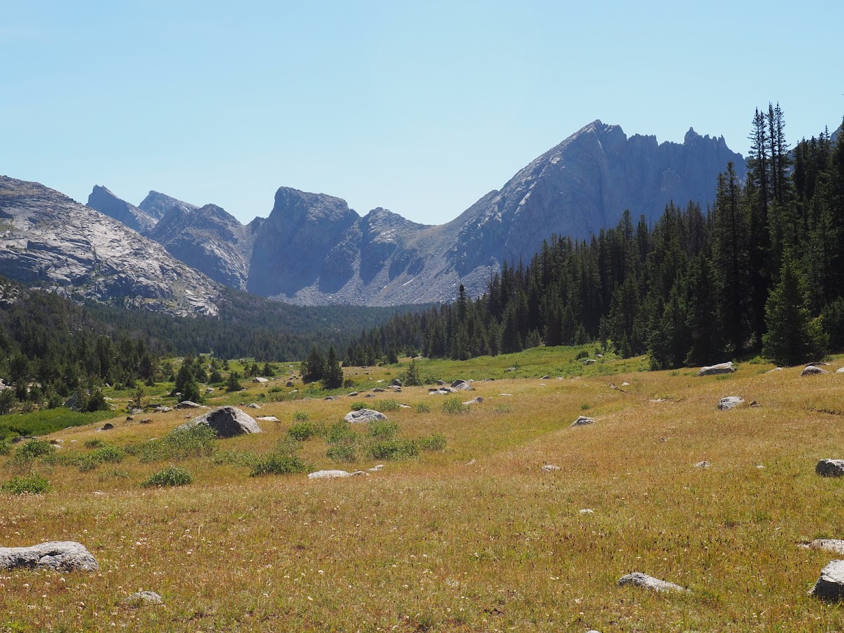
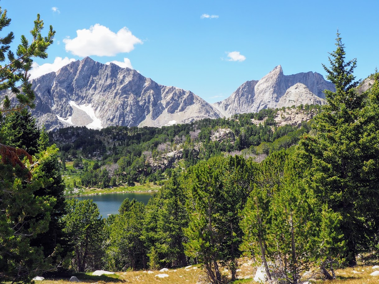
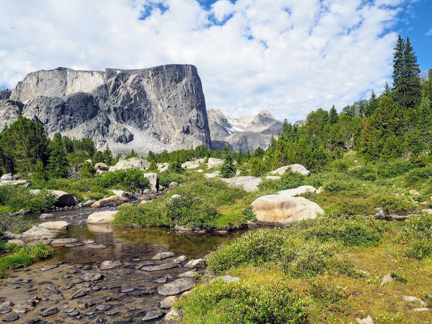
It's about 7 miles from the trail head to Marms lake, the trail heads up hill for awhile then hits some meadows followed by more uphill and you finally reach Dad's lake. Dad's lake is pretty and there looked like some good camping but I wanted to get farther in. Marms lake is only about a mile from Dads lake but that last mile sort of did me in. I started getting very winded and pretty dizzy. But I pushed on and finally made it to Marms lake.

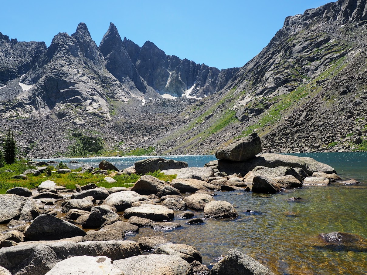
Once I reached Marms lake I had to find suitable camping. As I surveyed the lake I could spot numerous tents. I noticed almost immediately some people were not really following the rules of camping 200 ft from lakes and rivers. I saw one site that people were within 10 ft of the lake. I always thought that you really want your camp to be out of sight of the trail and other campers.

So finding a site I wanted to find something that was private and not visible but also an acceptable distance to the lake. I finally found a site above the lake and on the opposite side of the trail.

My camp at Marms lake. The trail is below my camp between lake and me. The ground was a bit lumpy and it was a pain getting water, but I do think this was pretty good spot to be in. It was private, there was a nice breeze and it had a fire pit on the rocks. Someone had even setup logs with that acted as a bench. (not exactly leave no trace though)
Image

You can kind of see the trail in the field below.
Image

Image

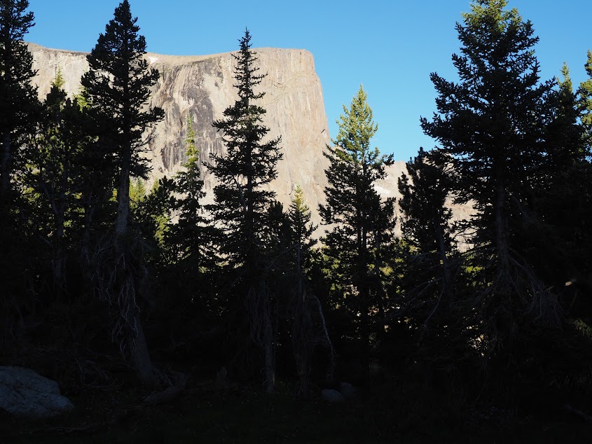
I didn't capture it hear very well, there were some mountains visible in the distance
Image

Ut-oh Equipment failure on my first day!
As I was blowing up my air mattress it wasn't holding air well and I heard hissing noise. I discovered it had a hole and was losing air pretty quick. Oh boy this could be a show stopper. I thought I had checked this before trip so maybe something happened to it while going through airport baggage.

It turns out I had a patch kit with me and Thank God it worked!

Stay tuned for Day 2!
We are in the mountains and the mountains are in us. - John Muir
PeteE
Posts: 3346
Joined: Tue Apr 08, 2014 12:20 pm
Gender?: Male
Please add the numbers(11): 11
Location: Winter hHaven Florida
Has thanked: 3 times
Been thanked: 1 time
Contact:

Re: Wind River Backpack TR

Post by PeteE »

Thanks Paul for posting your report and looking forward to the rest.
I really, really want to get down to the Wind River and/or the Beartooth Range before I'm too old and feeble.
I do worry some about the altitude issue. Living at 3000ft doesn't really acclimate one any better than living at sea level.
https://hypoxico.com/altitude-to-oxygen-chart/
Glad to know you had the patch kit :)

pete :wink:
"If you are not curious, you will learn nothing" -Goethe-

"When you're born in this world, you're given a ticket to the freak show.
And when you're born in America, you're given a front row seat."

George Carlin
User avatar
paul
Donator
Donator
Posts: 1705
Joined: Tue Oct 10, 2006 7:42 pm
Gender?: Male
Please add the numbers(11): 11
Location: MA
Has thanked: 66 times
Been thanked: 46 times

Re: Wind River Backpack TR

Post by paul »

PeteE wrote: Mon Sep 07, 2020 3:10 pm Thanks Paul for posting your report and looking forward to the rest.
I really, really want to get down to the Wind River and/or the Beartooth Range before I'm too old and feeble.
I do worry some about the altitude issue. Living at 3000ft doesn't really acclimate one any better than living at sea level.
https://hypoxico.com/altitude-to-oxygen-chart/
Glad to know you had the patch kit :)

pete :wink:
Thanks Pete,

Next time I do a trip like this I'm going to take a few days to acclimate. They say it takes 3 days or so to get used to a new altitude. If you are going to go to the Winds, there are some good car campgrounds that you can use as a base to acclimated. I went to the Green River lakes TH and there's a good camping there and really good scenery.

Paul
We are in the mountains and the mountains are in us. - John Muir
User avatar
paul
Donator
Donator
Posts: 1705
Joined: Tue Oct 10, 2006 7:42 pm
Gender?: Male
Please add the numbers(11): 11
Location: MA
Has thanked: 66 times
Been thanked: 46 times

Re: Wind River Backpack TR

Post by paul »

August 9, Day 02 Day Hike to Shadow Lake

I planned a day off to acclimate and I'm glad I did because I wasn't feeling ready to put on a heavy pack on day 2. I was still feeling a little dizzy and both legs had some injuries. My right leg had achilles tendon pain and my left calf was hurting. So I was glad I my agenda had for me was a 7 mile day hike to Shadow Lake and back.

Shadow lake lies in a valley on the opposite side of the Cirque of Towers (the most popular scenic area of the Wind River Range.) So I would be visiting the other side of cirque and it would probably be very nice.

My camp was on the north end of Marms lake so I would be closer to where I needed to go. The path to Shadow lake follows the Pyramid lake trail north to Washakie creek and the junction of the Shadow lake trail. As you head north from Marms lake the trail enters a small ravine and climbs gently for a half mile or so before leveling out somewhat on very since rolling meadow area where there are mountains views in numerous directions.

Once out of the ravine the mountains come into clear view
Image

Image

As you hike the views continue to get better. This view is in the direction of where I would be going on Day 3
Image

Image

Image

About a mile and a half from Marms lake you reach the trail junction for Shadow Lake, this is just before you reach the creek. The Shadow lake trail follows the creek east toward Shadow Lake. It's a really nice section of trail, easy hiking with great scenery,

On the Shadow lake trail
Image

Image

Image

Image

As you near Shadow Lake the spires of the Cirque of Towers become more defined. (I still need to see the other side of this)
Image

Along the trail heading toward Shadow lake. At this point the creek is on the right, the trail crossed the creek a little bit earlier.
Image

Shadow lake is behind those trees. If you look up in the image you see some passes. Both look pretty gnarly to me. For awhile there I thought that one of those was Texas pass which is used by backpackers to get to the other side of the cirque. I was glad to find out that neither of these was Texas Pass.
Image

The scenery at Shadow lake is quite impressive. Definitely up to Glacier standards and then some with views in many directions
Image

Image

Image

Image

Image

Some video of Shadow lake. The video is very good I have to remember to zoom in and out slowing and try to keep my camera steady. While I was shooting the first videw there was plane flying over head, so I took another video just to be sure I got a more serine video.
https://photos.google.com/share/AF1QipP ... pxTUxnTkhR

https://photos.google.com/share/AF1QipP ... pxTUxnTkhR

I had some lunch at Shadow lake and retraced my back to camp. It was good to get back at camp early and rest up for the next day.
We are in the mountains and the mountains are in us. - John Muir
User avatar
tibber
2.0 Donator
2.0 Donator
Posts: 477
Joined: Thu Jul 08, 2010 11:50 am
Gender?: Female
Please add the numbers(11): 11
Location: Phoenix, AZ
Has thanked: 78 times
Been thanked: 31 times

Re: Wind River Backpack TR

Post by tibber »

looks so pretty and nice trail too. Thx for sharing.
User avatar
paul
Donator
Donator
Posts: 1705
Joined: Tue Oct 10, 2006 7:42 pm
Gender?: Male
Please add the numbers(11): 11
Location: MA
Has thanked: 66 times
Been thanked: 46 times

Re: Wind River Backpack TR

Post by paul »

tibber wrote: Tue Sep 08, 2020 8:50 pm looks so pretty and nice trail too. Thx for sharing.
Thanks Tibber!
We are in the mountains and the mountains are in us. - John Muir
User avatar
paul
Donator
Donator
Posts: 1705
Joined: Tue Oct 10, 2006 7:42 pm
Gender?: Male
Please add the numbers(11): 11
Location: MA
Has thanked: 66 times
Been thanked: 46 times

Re: Wind River Backpack TR

Post by paul »

August 10 - Day 3

My plan for the third day was to head up and over Hailey pass and then over to Baptiste lake. I knew this hike was going to be tough, I've never carried a heavy backpack over a pass higher than Boulder pass. Hailey pass is around 11, 200ft. My camp at Marms lake is at 9800 ft and I'm still feeling the effects of the altitude.

The first mile and half of the hike follows the same path as I did on Day 2's hike. I followed the pyramid lake trail to Washakie Creek. After crossing the creek the trail begins to climb. I wouldn't see much flat or downhill terrain for awhile.

The trail to Hailey pass splits from the pyramid lake trail about 2 miles from the creek.

The view looking west on the trail to Hailey pass. I'm not sure if this is Pyramid Peak to Mt Greike. The lake below is Maes Lake.
Image

To the right of Pyramid is a another mountain which I thinking is Raid Peak.
Image

The farther I hiked up the trail, the harder it got. Near the top, I lost the trail for a few minutes. I followed an offshoot of the real trail where other hikers went the wrong way. The trail then peters out to nothing so your are left to either backtrack or find the trail by some other means. As I was looking for the real trail I saw 3 hikers about 200 yards away. I shouted "where's the trail?" And one of them pointed in the general direction I should go. So I made diagonal to that point and found the trail. At this point there are no trees, just rocks and you know where the pass is and the general direction you need to go.

After picking up the trail again, I continued on and found that it made a crazy detour up a steep climb and then straight down a 150 foot shoot. I was no longer hiking, I was mountain climbing! I think I read somewhere where the trail to Hailey pass had to detoured because of a recent rock fall. Anyway, I made it down the shoot and pass now was very close. Just as I reached the pass the 3 hikers behind me caught up. What timing!

Sign marking Hailey Pass
Image

Unfortunately pretty much all my pictures at Hailey Pass had the 3 hikers in the them. I didn't take too much time at the pass because it was windy and cold and it weather was going downhill fast.
Image

This is looking sort of north west from the pass. It looks like one could scramble up Mount Hooker by getting through the bowl of talus and then following the ridge.
Image

Image

Image

Image

Image


In hindsight I really wish I took more time taking pictures on this trip. Taking pictures was more difficult because a lot times my camera was in my pack because of the threat of rain. So in order to take pictures I had to stop and take off my pack and then dig my camera out.

The trail down from Hailey pass on the other side was incredibly steep for the first half mile or so. It was hard to keep my feet under me and I was glad to have hiking poles. The trail then goes into a more gradual decent. However at this point the weather got bad and it rained and hailed on me. It would have been nice to take some pictures here because there were many scenic views on the way down.

As I was hiking down I saw probably 5 or 6 tents on the side of mountain. These were climber camps for Mount hooker.

The trail finally reaches bottom at Baptiste creek where you need to cross to continue on to Baptiste lake. I was wiped out at this point and I decided there's no way I was going to go to Baptiste lake today because I would need to regain another 400 ft of elevation and hike 2 more miles. So I decided to find a camp somewhere in the area. This took much longer than it should have. I probably spent the next hour and half looking for a decent spot and then setting up my tent. Oh well!

After that I was so beat I just ate some quickly and went to bed. This was definitely the most difficult backpacking day of life.
Last edited by paul on Tue Sep 15, 2020 8:30 pm, edited 1 time in total.
We are in the mountains and the mountains are in us. - John Muir
McKee80
Donator
Donator
Posts: 129
Joined: Thu Feb 09, 2017 5:30 pm
Gender?: Male
Please add the numbers(11): 11

Re: Wind River Backpack TR

Post by McKee80 »

Awesome! This is on my list to do in the next couple years. Love the pictures and enjoying the backpacking struggle!
User avatar
paul
Donator
Donator
Posts: 1705
Joined: Tue Oct 10, 2006 7:42 pm
Gender?: Male
Please add the numbers(11): 11
Location: MA
Has thanked: 66 times
Been thanked: 46 times

Re: Wind River Backpack TR

Post by paul »

Thanks Mckee,

I fixed some of the image links in my last post. Let me know if they don't show up.

Paul
We are in the mountains and the mountains are in us. - John Muir
PeteE
Posts: 3346
Joined: Tue Apr 08, 2014 12:20 pm
Gender?: Male
Please add the numbers(11): 11
Location: Winter hHaven Florida
Has thanked: 3 times
Been thanked: 1 time
Contact:

Re: Wind River Backpack TR

Post by PeteE »

Paul:

Pics working great and are beautiful.
I love that terrain. I would love to get down there for a backpacking trip.
Like you, my concern would be acclimating my not so hot lungs to the elevation.
O2 percentage here in Kalispell at 3000ft is ~18.6%
At 10,000-11,000ft it's down to ~14%...that's about a 25% drop :shock:
https://hypoxico.com/altitude-to-oxygen-chart/

Liking your trip report!
pete :wink:
"If you are not curious, you will learn nothing" -Goethe-

"When you're born in this world, you're given a ticket to the freak show.
And when you're born in America, you're given a front row seat."

George Carlin
User avatar
paul
Donator
Donator
Posts: 1705
Joined: Tue Oct 10, 2006 7:42 pm
Gender?: Male
Please add the numbers(11): 11
Location: MA
Has thanked: 66 times
Been thanked: 46 times

Re: Wind River Backpack TR

Post by paul »

PeteE wrote: Tue Sep 15, 2020 8:58 pm Paul:

Pics working great and are beautiful.
I love that terrain. I would love to get down there for a backpacking trip.
Like you, my concern would be acclimating my not so hot lungs to the elevation.
O2 percentage here in Kalispell at 3000ft is ~18.6%
At 10,000-11,000ft it's down to ~14%...that's about a 25% drop :shock:
https://hypoxico.com/altitude-to-oxygen-chart/

Liking your trip report!
pete :wink:
Thanks Pete,

Yeah the altitude really created some problems for me I didn't spend enough time getting acclimated before really exerting too much on my first day. If I go back there I'm going to car camp for a few days and do some easy day hikes. I'm also not going to be so ambitious with the number of days so I can lower the weight of pack. Little things like that can make big difference.
We are in the mountains and the mountains are in us. - John Muir
User avatar
paul
Donator
Donator
Posts: 1705
Joined: Tue Oct 10, 2006 7:42 pm
Gender?: Male
Please add the numbers(11): 11
Location: MA
Has thanked: 66 times
Been thanked: 46 times

Re: Wind River Backpack TR

Post by paul »

August 11 Day 4

Day 4 was supposed to be from Baptiste Lake to somewhere along the south fork of the Little Wind River. Since I didn't make it to Baptiste lake my hike would be 2 miles shorter. (Baptiste lake would have put me further away from destination).

My camp was sort of in an opening in the woods up slope from the Baptiste creek crossing the trail.

From my camp I could see the great cliff of Mount Hooker through trees.
Image

Image

Image

A better view of Mt Hooker one I got out from the trees. Mt Hooker is one of the reasons why I selected this hike. It is the El capitan of the Wind River Range. It has a 1200+ foot cliff of granite which climbers from all parts of the country come to climb. I like it just because it's an incredible thing to see.
Image

Image

From Baptiste creek
Image

Image

Image

After packing up camp I headed down to get water and take pictures at Baptiste creek. This is one of those places where you can't cross the stream by rock hopping. You can rock hop part of the way but then there are channels of water that aren't passable be jumping on rocks. So you have to take the time to put on some water shoes and cross through stream. This is a pain but beats falling in the water or getting wet boots to begin your day.

Once past Baptiste creek I followed the Bears trail around the north side of Grave lake to the eastern shores. The trail is rocky and climbs about 200 ft above the lake at point you only see the lake when on the ridge, otherwise you are in the woods most of the time.

Once I reached the eastern shores of Grave lake I stopped to have some lunch. This is the only picture I took. You don't see it in the picture but shoreline from where I took the picture is all sand. It would have make a nice camping area.
Image

After lunch I stayed on Bears Ears trail, the next 2 hours of hiking I felt really bad. I don't know why I guess I was just worn out from the previous day's hike. The trail climbed over some ridges in the woods before dropping down to the South fork of the Little Wind River. It was in that section of hiking that I decided to change my route from going up to Lizard head plateau to just going up to Washakie pass and hiking back the way I started the hike. I just thought that if I went to Lizard head it would mean climbing 2 more passes of 11500+ ft as opposed to just one pass
of the height. I wasn't certain I could even do one more high pass at that point so that's why I decide to cut the trip short.

The Bears ears trail intersects with the South Fork of the Little Wind River and then continues on east. Once you hit the river there is a trail that follows the river south, it's not on any map that I had nor was it on my GPS. But it was a very good trail despite that. The hiking was flat and the woods quickly gave way to meadows. I felt better already (maybe it was because I was down below 10000 ft for the first time in 2 days). I had planned to camp somewhere in the rolling meadows along the river. I knew I would have nice views of Buffalo head.

It didn't take long for me to find a good spot. I seemed to almost have the place to myself. There were a couple of campers but they were well hidden from my view.

Some views from my camp of Buffalo Head and the south. There were thunder storms in the mountains but I never got any rain, just wind.
Image

Image

Image

Image

Image

Image

Looking down at the river and trail from my camp
Image

My camp was really nice. It was private, had great views and there was even a bear box there for me to put my food in. No hanging food tonight! (I believe this was camp for outfitters/hunters because there was bear box and also a carcass hanging pole. But since there were no outfitters around I felt like it was fine for me to use)

This was taken the next morning. But it give you and idea of what my camp was like:
Image
We are in the mountains and the mountains are in us. - John Muir
User avatar
MISSY
Donator
Donator
Posts: 431
Joined: Thu Jul 31, 2008 1:50 pm
Please add the numbers(11): 0
Location: College Station, Texas
Has thanked: 25 times
Been thanked: 2 times

Re: Wind River Backpack TR

Post by MISSY »

Enjoying your trip report. Thanks for taking us along. Great details! We are flatlanders here in our part of Texas. Altitude is always a struggle.
Thanks,
MISSY
PeteE
Posts: 3346
Joined: Tue Apr 08, 2014 12:20 pm
Gender?: Male
Please add the numbers(11): 11
Location: Winter hHaven Florida
Has thanked: 3 times
Been thanked: 1 time
Contact:

Re: Wind River Backpack TR

Post by PeteE »

Very nice report Paul.
That's really beautiful country.
Your advice on acclimating to the altitude will help me a lot.
One question...
In treeless areas, where/how did you store/hang your food?

I've decided to put everything else aside to make a trip down to either the Wind River or the Beartooth Range.
Thank you for all the information on the things you learned.
It'll be a big help for me.

pete :wink:
"If you are not curious, you will learn nothing" -Goethe-

"When you're born in this world, you're given a ticket to the freak show.
And when you're born in America, you're given a front row seat."

George Carlin
User avatar
paul
Donator
Donator
Posts: 1705
Joined: Tue Oct 10, 2006 7:42 pm
Gender?: Male
Please add the numbers(11): 11
Location: MA
Has thanked: 66 times
Been thanked: 46 times

Re: Wind River Backpack TR

Post by paul »

PeteE wrote: Sun Sep 20, 2020 4:30 pm Very nice report Paul.
That's really beautiful country.
Your advice on acclimating to the altitude will help me a lot.
One question...
In treeless areas, where/how did you store/hang your food?

I've decided to put everything else aside to make a trip down to either the Wind River or the Beartooth Range.
Thank you for all the information on the things you learned.
It'll be a big help for me.

pete :wink:
Thanks Pete,

I didn't camp in places that had no trees to hang food. Even the camp that had the bearbox had trees big enough for the job. They say if there are no trees around you're supposed to hang your food off a cliff of some sort. The other option is to have bear canister or an ursack.

I'm not sure I would camp in a place above treeline anyway, each day that i was there it stormed in the afternoon and you really don't want to be too exposed in those storms.

I definitely liked the Wind River area better than the Beartooth range. There are good books for both. Let me know if you have questions. There is nothing like exploring places for the first time.

Paul
We are in the mountains and the mountains are in us. - John Muir
Post Reply

Return to “Non Park Specific Topics”