 Glacier Park Chat
A year late (still licking my wounds) but better than never. I had never been to Two Medicine before (for shame, I know). 5 night, 6 day inner trail to gunsight pass in September.
The challenge this year was logistics, with the park and contractors having staffing issues such that transportation options were limited. The park shuttle was ticketed (and sold out by the time permits were available). The contractor shuttles weren't offered. Flathead bus from Kalispell also wasn't running. Rental car prices were sky high, so wanted to do this with max one car if at all possible.
Itinerary:
ENTER - TWO MEDICINE NORTH SHORE (TRAILHEAD)
8-30-2021 - NON - NO NAME LK
Fires; NO
Segment; Length 5.00
Elevation; Up 1230 | Down 448
8-31-2021 - MOR - MORNING STAR
Fires; NO
Segment; Length 8.60
Elevation; Up 2175 | Down 1877
9-1-2021 - REF - RED EAGLE, FT
Fires; YES
Segment; Length 14.70
Elevation; Up 2080 | Down 3080
9-2-2021 - REY - REYNOLDS
Fires; YES
Segment; Length 14.30
Elevation; Up 400 | Down 500
9-3-2021 - ELL - ELLEN WILSON
Fires; NO
Segment; Length 9.90
Elevation; Up 2170 | Down 1017
EXIT - SPERRY TRAIL (TRAILHEAD)
Segment; Length 9.10
Elevation; Up 1467 | Down 4171
TOTALS;
Trip length 61.60 miles
Elevation up 9,522 feet
Elevation down 11,093 feet

GNP 2021 - TNE to STE
-
zozeppelin
- Special Contributor

- Posts: 431
- Joined: Sat Apr 06, 2019 5:53 pm
- Gender?: Male
- Please add the numbers(11): 11
- Has thanked: 103 times
- Been thanked: 59 times
-
zozeppelin
- Special Contributor
- Posts: 431
- Joined: Sat Apr 06, 2019 5:53 pm
- Gender?: Male
- Please add the numbers(11): 11
- Has thanked: 103 times
- Been thanked: 59 times
Re: GNP 2021 - TNE to STE
Day 0
So after calling around I found that the Pursuit east side shuttle (East Glacier to Two Medicine) was indeed running, so I made a reservation and build our arrival plan around Amtrak from Whitefish. I'm a 'trust buy verify' person as well as had concerns about our flammables (bear spray, stove fuel) and the train rules. So we ran over to East Glacier the day prior to drop off our flammables at the hotel for pickup the next day.
So the logistics plan went as follows:
Two cars from airport, one for a week, one for a day.
Hotel at Whitefish (Townplace Suites)
Drop flammables at Glacier Park Lodge and confirm shuttle for next day.
Drop 'week' car at Lake McDonald
Return to airport with 'day' car
Hotel shuttle from airport to Whitefish (free!)
Then day of hike:
Hotel shuttle to Whitefish Amtrak station
Amtrak to East Glacier
Pursuit shuttle to Two Medicine
Success!
This all worked out perfect, and I enjoyed the 'planes, trains and automobiles' aspect of it.
Our first day was short and had taxi backup plans worst case, but was a little eerie being without a car in hand from the night before until the end.
Of note is that the I use white gas (Coleman fuel) for my stove instead of the normal gas canisters, so I was pessimistic of East Glacier or Two Medicine having it, altough did assume they'd have bear spray. I called Glacier Park Trading Company and they confirmed they did not have white gas. Since we had some time, I scoped them out upon arrival and did find Glacier Park Trading Company to have white gas, along with pretty much everything else (water filtration, stoves, bear spray, etc). The lodge and Two Medicine general store did not have white gas.
Edit to add, when we were picking up our permit at Two Medicine, the ranger's radio broadcasted that Many Glacier just went hard sided only. I only mention this because that is a really unfortunate situation for hikers going through Many Glacier, as there is no alternative, and moreso since the trail status and closures pages were down, no one would have been any the wiser until picking up their permit. I wish the park would move the backcountry site out of the campground such that front country restrictions don't blow up backcountry itineraries. That or allow backcountry campers exemption as they have training and signed the permit that they will abide by proper food storage and preparation rules.
Last edited by zozeppelin on Sun Oct 09, 2022 11:57 am, edited 2 times in total.
-
zozeppelin
- Special Contributor
- Posts: 431
- Joined: Sat Apr 06, 2019 5:53 pm
- Gender?: Male
- Please add the numbers(11): 11
- Has thanked: 103 times
- Been thanked: 59 times
Re: GNP 2021 - TNE to STE
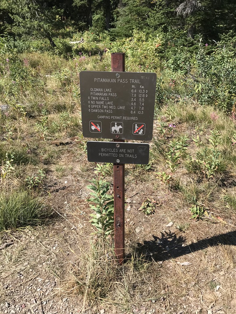
Day 1
Itinerary: Two Medicine to No Name Lake (starting in Whitefish)
Mileage: 5
Elevation Gain: 1230
Elevation Loss: 448
Bear locker: no
Fires: no
Short first day to ease into things, which was good because I wasn't very physically prepared (no gym) and in case there were transportation issues.
As I mentioned in the prelude, this was the planes, trains and automobiles day ... well the planes was the day prior, but you get the point.
Stage 1: Townplace Suites to Whitefish Train Station via hotel shuttle.

Stage 2: Whitefish Train Station to East Glacier Train Station via Amtrak

Stage 3: Glacier Park Lodge to Two Medicine via Pursuit

All went really well, we arrived on time to East Glacier, walked to Glacier Park Lodge, picked up our flammables, and were able to get on an earlier shuttle. Arrived Two Medicine with plenty of time, so grabbed a sandwich and coffee at the general store while making final preparations. Today (or tomorrow) was the last day the store was open for the season. Our Pursuit shuttle driver was second generation seasonal working - really cool to hear about how he was brought up working summers here with the family - you could tell it meant a lot.
Tradition is to bring a bottle of scotch on the hike, and this is from a non-hard alcohol drinker. When I first started hiking I'd bring beer, and wine (sometimes box, sometimes bottle), but that wasn't very weight smart and then have to content with the trash aspect as well, so I've gotten 'smarter'. The point of this was to put a plug in for Flathead liquors in Kalispell. I always have no idea what I'm picking, but the guy working there is great making some recommendations and letting us figure it out.

So final preparations complete (flammables into containers) - upwards and onwards we go.
I've never been to Two Medicine (except the day prior to pickup the permit), so it was really nice taking it in.

Hiking was uneventful, but some nice views (I think this is Pumpelly pillar)

Finally, made it to camp, which was empty as expected as it was early. I usually like to take a plunge, but it didn't look too inviting and it was the first day so didn't feel too filthy. While getting water, the next party arrived camp.
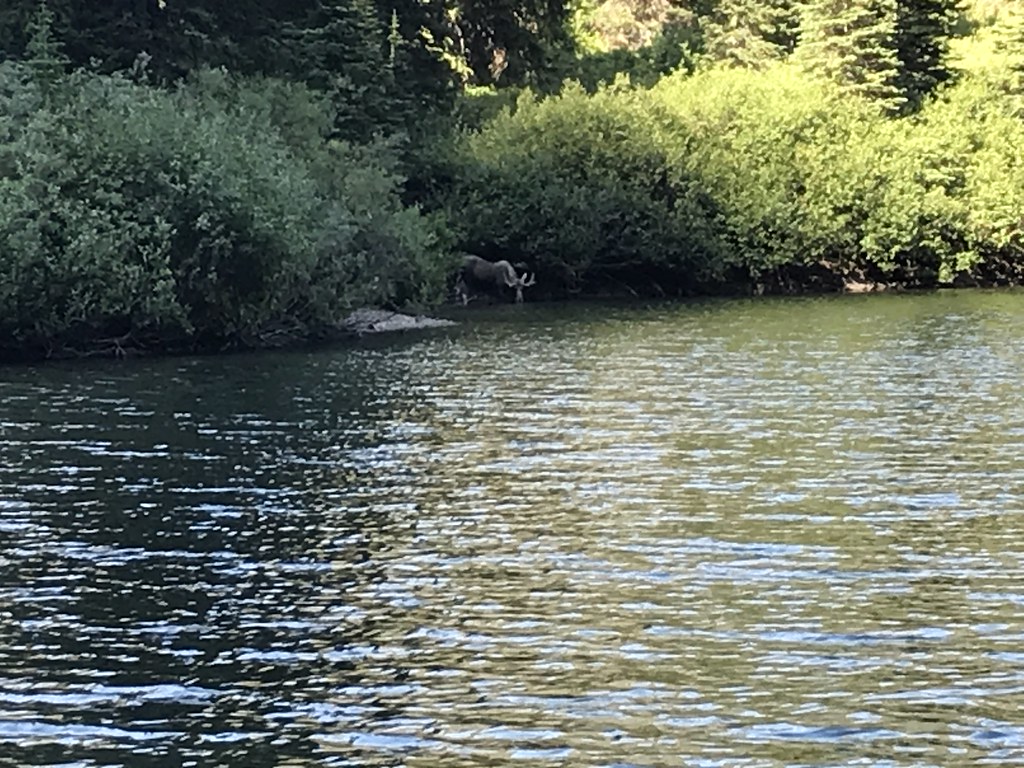
Eventually the other campers arrived - an off-duty glacier guide and her friends and another couple from WI. The guy from WI (not originally) had a pistol, which I don't know why that bothered me, but it did. Probably somewhere between it being illegal to discharge a fire arm in the park (why bring something dangerous you can't legally use) and that fire arm probably having no effect on the intended target (bear or moose would care less ... maybe a mountain lion?). The moose ended up hanging around camp a bit. All and all a great day and start.

Itinerary: Two Medicine to No Name Lake (starting in Whitefish)
Mileage: 5
Elevation Gain: 1230
Elevation Loss: 448
Bear locker: no
Fires: no
Short first day to ease into things, which was good because I wasn't very physically prepared (no gym) and in case there were transportation issues.
As I mentioned in the prelude, this was the planes, trains and automobiles day ... well the planes was the day prior, but you get the point.
Stage 1: Townplace Suites to Whitefish Train Station via hotel shuttle.
Stage 2: Whitefish Train Station to East Glacier Train Station via Amtrak
Stage 3: Glacier Park Lodge to Two Medicine via Pursuit
All went really well, we arrived on time to East Glacier, walked to Glacier Park Lodge, picked up our flammables, and were able to get on an earlier shuttle. Arrived Two Medicine with plenty of time, so grabbed a sandwich and coffee at the general store while making final preparations. Today (or tomorrow) was the last day the store was open for the season. Our Pursuit shuttle driver was second generation seasonal working - really cool to hear about how he was brought up working summers here with the family - you could tell it meant a lot.
Tradition is to bring a bottle of scotch on the hike, and this is from a non-hard alcohol drinker. When I first started hiking I'd bring beer, and wine (sometimes box, sometimes bottle), but that wasn't very weight smart and then have to content with the trash aspect as well, so I've gotten 'smarter'. The point of this was to put a plug in for Flathead liquors in Kalispell. I always have no idea what I'm picking, but the guy working there is great making some recommendations and letting us figure it out.
So final preparations complete (flammables into containers) - upwards and onwards we go.
I've never been to Two Medicine (except the day prior to pickup the permit), so it was really nice taking it in.
Hiking was uneventful, but some nice views (I think this is Pumpelly pillar)
Finally, made it to camp, which was empty as expected as it was early. I usually like to take a plunge, but it didn't look too inviting and it was the first day so didn't feel too filthy. While getting water, the next party arrived camp.
Eventually the other campers arrived - an off-duty glacier guide and her friends and another couple from WI. The guy from WI (not originally) had a pistol, which I don't know why that bothered me, but it did. Probably somewhere between it being illegal to discharge a fire arm in the park (why bring something dangerous you can't legally use) and that fire arm probably having no effect on the intended target (bear or moose would care less ... maybe a mountain lion?). The moose ended up hanging around camp a bit. All and all a great day and start.
Last edited by zozeppelin on Sun Oct 09, 2022 11:48 am, edited 1 time in total.
-
zozeppelin
- Special Contributor
- Posts: 431
- Joined: Sat Apr 06, 2019 5:53 pm
- Gender?: Male
- Please add the numbers(11): 11
- Has thanked: 103 times
- Been thanked: 59 times
Re: GNP 2021 - TNE to STE
Day 2
Itinerary: No Name Lake to Morning Star Lake
Mileage: 8.6
Elevation Gain: 2175
Elevation Loss: 1877
Bear locker: no
Fires: no
Today was the day I was looking forward to most of the trip with Dawson, then Pitamakan passes. A relatively short day again, but our first real elevation gain and loss, so wanted an early start to take it easy.

Climb wasn't too bad, some nice views looking back.

Of all the views, I think my favorite was looking backwards (southward) once over the pass.

Mt Phillips to the west (running parallel to the trail).
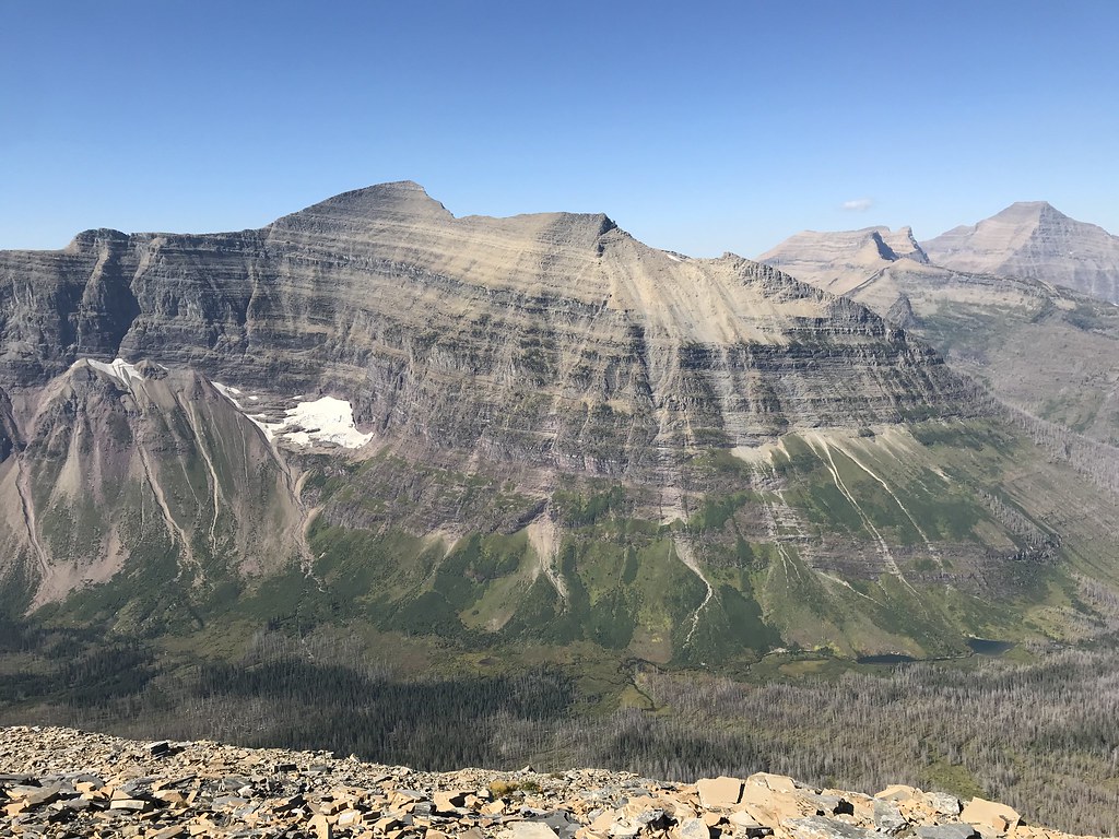
Looking forward (north) into the valley (Nyack loop):

Nice contrast with 'little' Tinkham in the foreground and Pinchot, Stimpson and Blackfoot in the background(?)
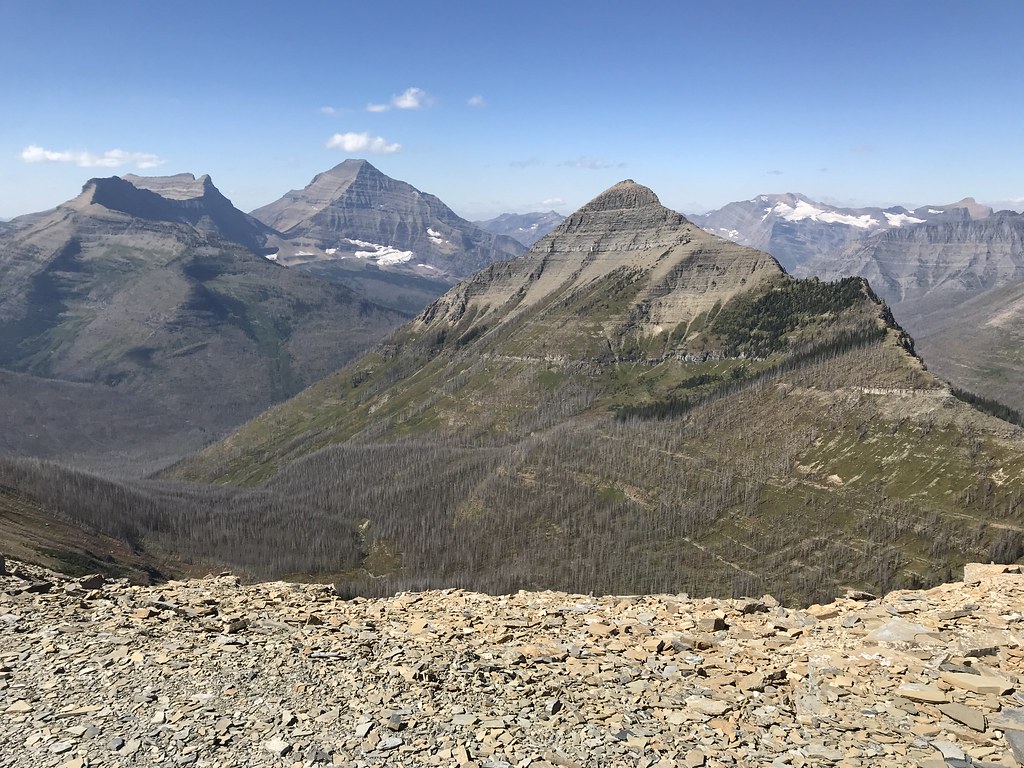
Finally made it across (more or less). A bit deceptive how hard, I was thinking highline type trail, but it did up / up and down quite a bit after Dawson Pass. It was pretty windy so that probably had something to do with it as well. Looking at Mt. Morgan and Oldman Lake.

One last look back (south).

Took lunch at the outcropping west of Mt Morgan.
And finally down we go towards Cut Bank. 'Stop and brace yourself' windy in the area between Cut Bank Pass and Pitamakan Pass.

Looking back up at the two passes from Pitamakan lake.

I would have rather stayed here at Pitamakan Lake than Morningstar, but it was nice.

Thought we were the only ones, until near dark another two came, then finally another after dark. The initial pair (Chicago, one from France originally) came from Beaver Woman Lake (Nyack Loop) and up over Cut Bank Pass. Said it was really bushy and lost the trail several times. Long day, hit tip to them. Caught up with the morning the other, was CDT and a really nice guy - we'd share sites the next two nights as well.
Itinerary: No Name Lake to Morning Star Lake
Mileage: 8.6
Elevation Gain: 2175
Elevation Loss: 1877
Bear locker: no
Fires: no
Today was the day I was looking forward to most of the trip with Dawson, then Pitamakan passes. A relatively short day again, but our first real elevation gain and loss, so wanted an early start to take it easy.
Climb wasn't too bad, some nice views looking back.
Of all the views, I think my favorite was looking backwards (southward) once over the pass.
Mt Phillips to the west (running parallel to the trail).
Looking forward (north) into the valley (Nyack loop):
Nice contrast with 'little' Tinkham in the foreground and Pinchot, Stimpson and Blackfoot in the background(?)
Finally made it across (more or less). A bit deceptive how hard, I was thinking highline type trail, but it did up / up and down quite a bit after Dawson Pass. It was pretty windy so that probably had something to do with it as well. Looking at Mt. Morgan and Oldman Lake.
One last look back (south).
Took lunch at the outcropping west of Mt Morgan.
And finally down we go towards Cut Bank. 'Stop and brace yourself' windy in the area between Cut Bank Pass and Pitamakan Pass.
Looking back up at the two passes from Pitamakan lake.
I would have rather stayed here at Pitamakan Lake than Morningstar, but it was nice.
Thought we were the only ones, until near dark another two came, then finally another after dark. The initial pair (Chicago, one from France originally) came from Beaver Woman Lake (Nyack Loop) and up over Cut Bank Pass. Said it was really bushy and lost the trail several times. Long day, hit tip to them. Caught up with the morning the other, was CDT and a really nice guy - we'd share sites the next two nights as well.
Last edited by zozeppelin on Sun Oct 09, 2022 3:01 pm, edited 1 time in total.
-
zozeppelin
- Special Contributor
- Posts: 431
- Joined: Sat Apr 06, 2019 5:53 pm
- Gender?: Male
- Please add the numbers(11): 11
- Has thanked: 103 times
- Been thanked: 59 times
Re: GNP 2021 - TNE to STE
Day 3
Itinerary: Morning Star Lake to Red Eagle Foot
Mileage: 14.7
Elevation Gain: 2080
Elevation Loss: 3080
Bear locker: no
Fires: yes
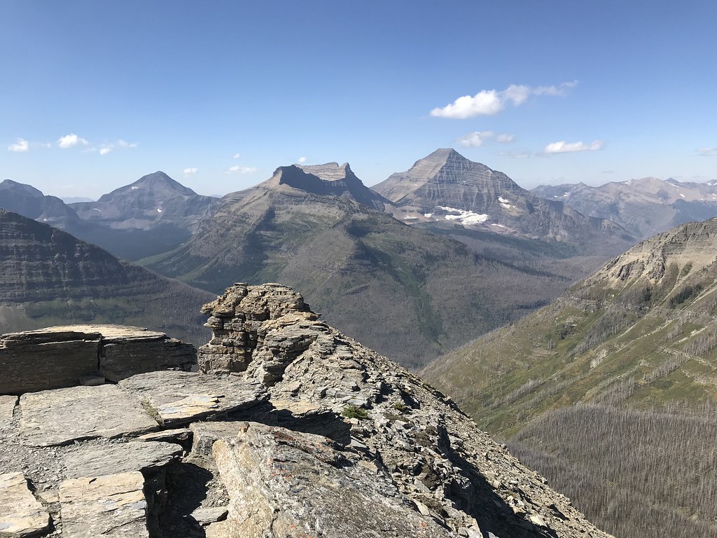
At the upper end of my ideal distance + elevation change, but no logical stops in the middle besides Atlantic Creek and that was too short (had considered camping here instead of Morning Star the night prior, glad I didn't). As someone who likes mountain passes, and especially 'new to me' mountain passes, Triple Divide was highly anticipated.
Everything was going well after the intersection to cut bank, with Medicine Grizzly lake visible.
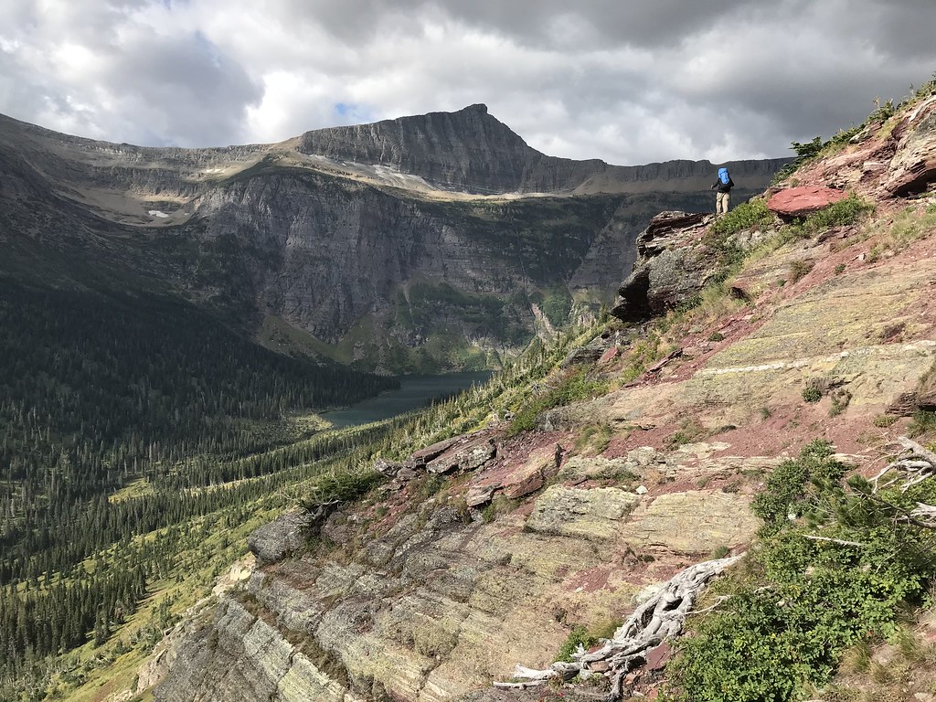
Then wind really started to pickup. The blow you off the mountain kind of wind and not the blow you up into the mountain kind of wind, which wasn't very fun. When it wasn't trying to blow you off the mountain, it was trying to blow you back down the trail. I bogged down a bit as I wanted to push through the cold as I was already warmed up from the easy trail thus far, but eventually had to stop and put on a jacket. So that wasn't ideal, but the views of the valley were great.

Triple Divide Pass was elusive, as it was hard to see with the trail continuing to bend around the mountain. This contributed to the delayed layering as it always seemed just over the next corner.
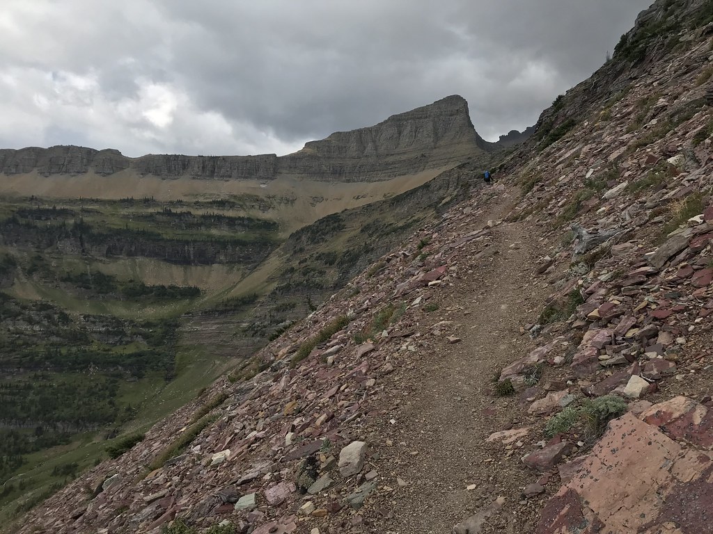
One last look back. Nice to see the shelf and ridge.

Lunch at the pass with obligatory picture.

Ok I lied, one last last look back. It's fun to think about what is on the other side and how to get there / what it connects to, which has become the theme of the trip.

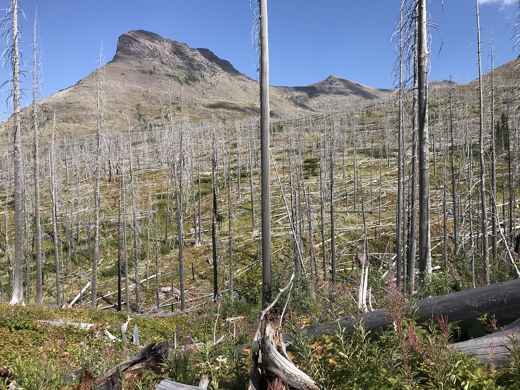
I forget where the hike down was uneventful or I was tired/wiped from the poor conditions on the ascent. I do like hiking in the burned out sections as it gives you better views and it kind-of eerie.

More burned out pictures with nice backdrops.
So technically these are next day pictures of the lake at sunrise, but I'll put them here. I like the contrast of some peaks getting sun and others not due to being shorter, but due to perspective appearing taller.


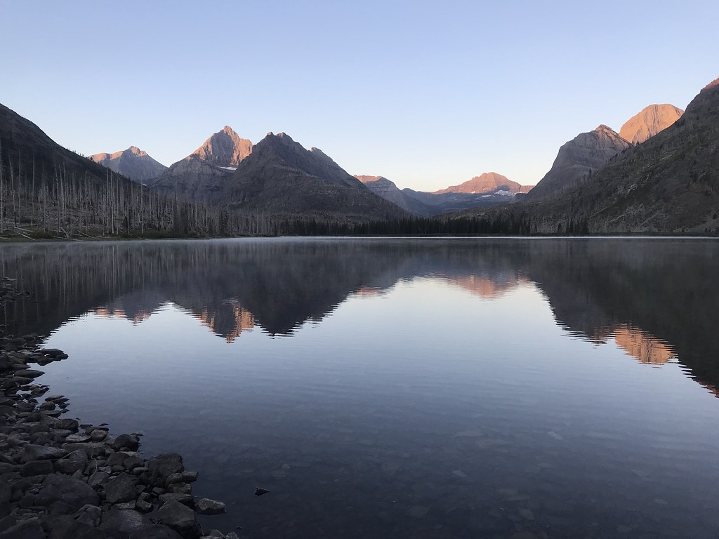

Overall, a nice campsite with great views, nice like and campground layout. The head didn't look at nice with debris and steeper shore.
Itinerary: Morning Star Lake to Red Eagle Foot
Mileage: 14.7
Elevation Gain: 2080
Elevation Loss: 3080
Bear locker: no
Fires: yes
At the upper end of my ideal distance + elevation change, but no logical stops in the middle besides Atlantic Creek and that was too short (had considered camping here instead of Morning Star the night prior, glad I didn't). As someone who likes mountain passes, and especially 'new to me' mountain passes, Triple Divide was highly anticipated.
Everything was going well after the intersection to cut bank, with Medicine Grizzly lake visible.
Then wind really started to pickup. The blow you off the mountain kind of wind and not the blow you up into the mountain kind of wind, which wasn't very fun. When it wasn't trying to blow you off the mountain, it was trying to blow you back down the trail. I bogged down a bit as I wanted to push through the cold as I was already warmed up from the easy trail thus far, but eventually had to stop and put on a jacket. So that wasn't ideal, but the views of the valley were great.
Triple Divide Pass was elusive, as it was hard to see with the trail continuing to bend around the mountain. This contributed to the delayed layering as it always seemed just over the next corner.
One last look back. Nice to see the shelf and ridge.
Lunch at the pass with obligatory picture.
Ok I lied, one last last look back. It's fun to think about what is on the other side and how to get there / what it connects to, which has become the theme of the trip.
I forget where the hike down was uneventful or I was tired/wiped from the poor conditions on the ascent. I do like hiking in the burned out sections as it gives you better views and it kind-of eerie.
More burned out pictures with nice backdrops.
So technically these are next day pictures of the lake at sunrise, but I'll put them here. I like the contrast of some peaks getting sun and others not due to being shorter, but due to perspective appearing taller.
Overall, a nice campsite with great views, nice like and campground layout. The head didn't look at nice with debris and steeper shore.
Last edited by zozeppelin on Sun Oct 23, 2022 6:44 pm, edited 1 time in total.
-
zozeppelin
- Special Contributor
- Posts: 431
- Joined: Sat Apr 06, 2019 5:53 pm
- Gender?: Male
- Please add the numbers(11): 11
- Has thanked: 103 times
- Been thanked: 59 times
Re: GNP 2021 - TNE to STE
Day 4
Itinerary: Red Eagle (Foot) to Reynolds Creek
Mileage: 14.3
Elevation Gain: 400
Elevation Loss: 500
Bear locker: no
Fires: yes
Today was supposed to be a long mileage day (for me), but relatively easy with minimal mileage gain, and should have been easier than the day prior going over triple divide pass.
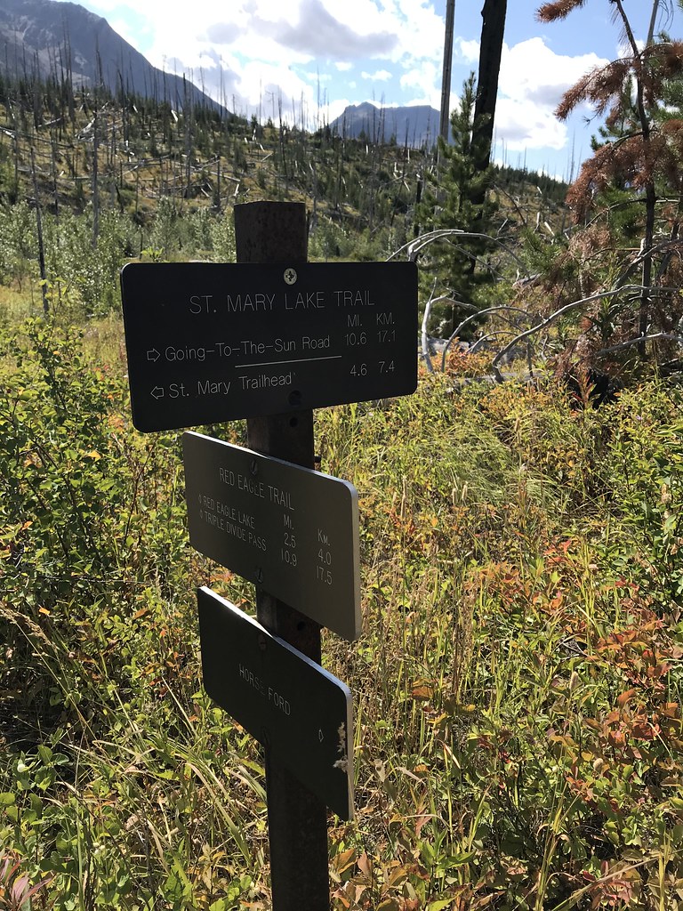
My hiking partner usually takes off before me to get a head start while I tear down camp and do final packing. I hike a little faster and enjoy the solo hiking, so it works out and I usually catch up within an hour or so. I have a GPS, but that really is just for recording tracks, as I stay on trail and the park has excellent trails and signage. I try to look at the map to start the day to visualize the path: sections / profile, intersections, distances, etc. For today I was expecting a T intersection with St Mary lake trail and taking a left (west) as that trail ran along the lake (east-west) and Red Eagle runs north-south.
There was frost this morning on the tent, at which point I finally decided to cave and buy gloves for next year, as cold and wet fingers in the morning is dumb having done it many times.
One last look at Red Eagle Lake before leaving camp:

The trail follows the Red Eagle Creek towards St Mary Lake, with some nice looks back if you don't forget:

There are a couple suspension bridges and you eventually break out of the area, with some good views towards Logan Pass:

So I was cruising pretty nicely, finally getting my hiking legs. At the bridges there was always a trail split prior for the horse ford. I'm not a big fan of the horses (acknowledging they helped make the park is what it is today), as all they do is destroy the trails and bad word everywhere, which is unpleasant to hike in, but also ignores LNT rules humans have to follow, but I digress. So several trail splits around visible bridges, which I ignore as I know those are just horse fords, and I don't even bother to look at as they annoy me.
Well time went on, maybe 2 hours in, and I began wondering where was the intersection. Then I started seeing hikers without packs coming my way - they couldn't possibly be going to Red Eagle like that I thought, and then the wheels began to turn. So I pulled on the GPS, and I was over half way to St Mary's Range Station. Let me tell you, not a great realization when your 14 mi day just turned into a 20 mile day, and you have to hustle to makeup time such that your hiking partner doesn't panic and backtrack towards the lake missing you. So went from high gear, to higher gear. It was going to be a long day.

Made it back to the missed interaction in about 45 minutes:
Some really nice views across the lake, but I wasn't in the mood to fully appreciate. Really the titans of GNP in my opinion, and my favorite areas of the park.

Eventually made it to the waterfalls. Always fun to intermix with the bathed people. I was in pretty rough shape after just having stopped for maybe 15 minutes all day to refill water and eat a snack, so I got some looks for sure. The burn section after the split towards Gunsight Pass Trail was a pretty cool views:

Just as I was nearing the river and bridge, I saw my hiking partner coming my way without pack. Needless to say, we were both glad to see each other, fearing the worst (he that I was injured/lost and me that he had backtracked past me before I reached the intersection). Good old Reynold's Creek bridge, 2 for 2 now as a sign of a long rough day.

Here is the velocity profile. Right around mile 6 is where I realized my folly. I was doing pretty well at 2.5 mi/h up to that point, and turned it up to 3.5 mi/h and maintained as long as I could, slowly running out of steam, but kept it above 2 the entire day for 20 miles.

Definitely pushed the knees beyond what they could do, so IT band / overuse issues plagued me the last 1/4 of the hike, and those would carry over to the next two days.
Itinerary: Red Eagle (Foot) to Reynolds Creek
Mileage: 14.3
Elevation Gain: 400
Elevation Loss: 500
Bear locker: no
Fires: yes
Today was supposed to be a long mileage day (for me), but relatively easy with minimal mileage gain, and should have been easier than the day prior going over triple divide pass.
My hiking partner usually takes off before me to get a head start while I tear down camp and do final packing. I hike a little faster and enjoy the solo hiking, so it works out and I usually catch up within an hour or so. I have a GPS, but that really is just for recording tracks, as I stay on trail and the park has excellent trails and signage. I try to look at the map to start the day to visualize the path: sections / profile, intersections, distances, etc. For today I was expecting a T intersection with St Mary lake trail and taking a left (west) as that trail ran along the lake (east-west) and Red Eagle runs north-south.
There was frost this morning on the tent, at which point I finally decided to cave and buy gloves for next year, as cold and wet fingers in the morning is dumb having done it many times.
One last look at Red Eagle Lake before leaving camp:
The trail follows the Red Eagle Creek towards St Mary Lake, with some nice looks back if you don't forget:
There are a couple suspension bridges and you eventually break out of the area, with some good views towards Logan Pass:
So I was cruising pretty nicely, finally getting my hiking legs. At the bridges there was always a trail split prior for the horse ford. I'm not a big fan of the horses (acknowledging they helped make the park is what it is today), as all they do is destroy the trails and bad word everywhere, which is unpleasant to hike in, but also ignores LNT rules humans have to follow, but I digress. So several trail splits around visible bridges, which I ignore as I know those are just horse fords, and I don't even bother to look at as they annoy me.
Well time went on, maybe 2 hours in, and I began wondering where was the intersection. Then I started seeing hikers without packs coming my way - they couldn't possibly be going to Red Eagle like that I thought, and then the wheels began to turn. So I pulled on the GPS, and I was over half way to St Mary's Range Station. Let me tell you, not a great realization when your 14 mi day just turned into a 20 mile day, and you have to hustle to makeup time such that your hiking partner doesn't panic and backtrack towards the lake missing you. So went from high gear, to higher gear. It was going to be a long day.
Made it back to the missed interaction in about 45 minutes:
Some really nice views across the lake, but I wasn't in the mood to fully appreciate. Really the titans of GNP in my opinion, and my favorite areas of the park.
Eventually made it to the waterfalls. Always fun to intermix with the bathed people. I was in pretty rough shape after just having stopped for maybe 15 minutes all day to refill water and eat a snack, so I got some looks for sure. The burn section after the split towards Gunsight Pass Trail was a pretty cool views:
Just as I was nearing the river and bridge, I saw my hiking partner coming my way without pack. Needless to say, we were both glad to see each other, fearing the worst (he that I was injured/lost and me that he had backtracked past me before I reached the intersection). Good old Reynold's Creek bridge, 2 for 2 now as a sign of a long rough day.
Here is the velocity profile. Right around mile 6 is where I realized my folly. I was doing pretty well at 2.5 mi/h up to that point, and turned it up to 3.5 mi/h and maintained as long as I could, slowly running out of steam, but kept it above 2 the entire day for 20 miles.
Definitely pushed the knees beyond what they could do, so IT band / overuse issues plagued me the last 1/4 of the hike, and those would carry over to the next two days.
Last edited by zozeppelin on Sun Nov 20, 2022 12:29 pm, edited 1 time in total.
-
zozeppelin
- Special Contributor
- Posts: 431
- Joined: Sat Apr 06, 2019 5:53 pm
- Gender?: Male
- Please add the numbers(11): 11
- Has thanked: 103 times
- Been thanked: 59 times
Re: GNP 2021 - TNE to STE
Day 5
Itinerary: Reynold's Creek to Lake Ellen Wilson
Mileage: 9.9
Elevation Gain: 2170
Elevation Loss: 1017
Bear locker: no
Fires: no
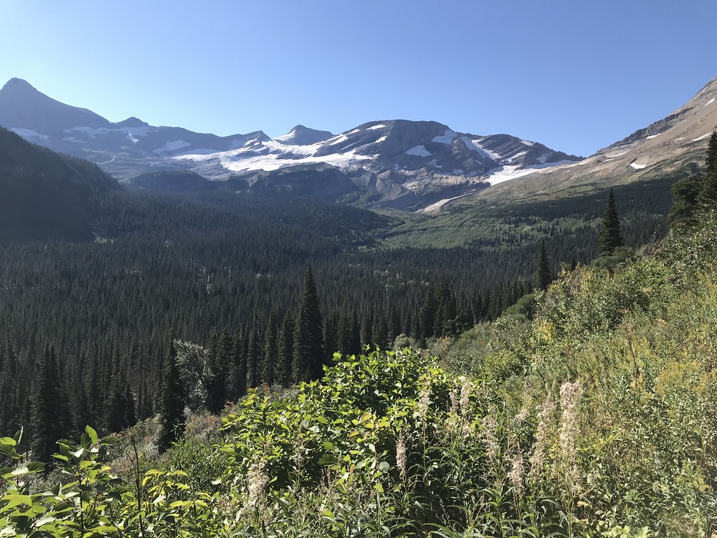
I had done Gunsight Pass before in the same direction, but this time it was much tougher than I recalled. We bid goodbye to CDT hiker (Rob) as he was going over Piegan and onward (I think to Granite Park or Lake Elizabeth - either way I was impressed and jealous as this would be the first and only time at GNP I hadn't gone over Piegan). Start was slow due to knee pain, that unfortunately didn't go away with warmup as hoped, so it was going to be a slog. Some nice views once up a bit and over the plain/bog area:

Continuing on, some nice views of the glacier:
The bridge was in at Gunsight Lake, so that was nice (it wasn't my last time):
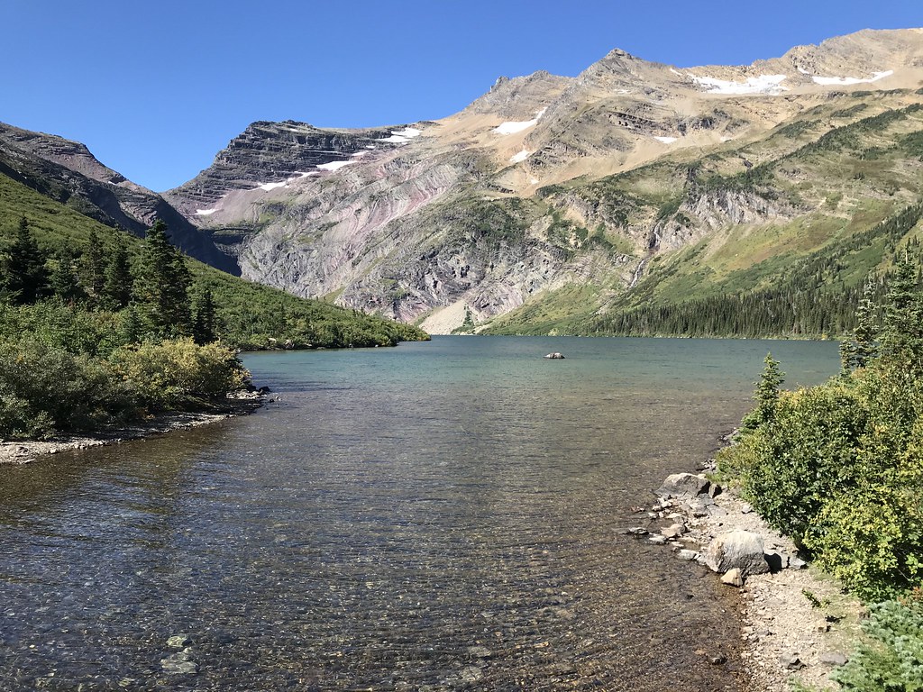
Something that really caught my attention was the geology, probably influenced by Tibber's trip reports last year. The sedimintary layers are quite visible and pretty here, especially due to the angle, presumably from the plate collision.

View of the pass, lake and geology.

Looking back at the late, some reason nice views behind:


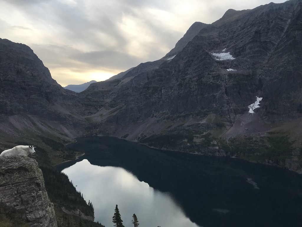
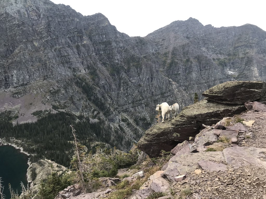
Finally made it up and over, then looking down on Lake Ellen Wilson. Not as nice without the sun, but the overhanging lake is one of my favorite features.

I've never stayed at this campground before, but it had always been on the list, so that was nice. We were forewarned about the goats eating everything, and not just sweat/salt related items, including the rangers tent fly - they advised not setting up until ready to use - which is annoying but not sure what can be done. The goats were prevalent and not shy. The spur trail to the campground was quite long and had some confusing areas where it was hard to tell trail from runoff / drainage. I was able to hop in the lake, which is always the target and helps rejuvenate aches and blisters (or maybe it's all in my head). Either way, really cold and really good.
On the way up to the pass, we were effectively caught by a couple of Mennonites(?) in traditional wardrobe (respect!). This was their honeymoon. They were staying at ELL as well that night. The other couple was doing a GUN-ELL-SPE, which is a really nice way to enjoy each great campground, having stayed in all of them now. And then there were the Chicago Karate friends. Good crew.
Itinerary: Reynold's Creek to Lake Ellen Wilson
Mileage: 9.9
Elevation Gain: 2170
Elevation Loss: 1017
Bear locker: no
Fires: no
I had done Gunsight Pass before in the same direction, but this time it was much tougher than I recalled. We bid goodbye to CDT hiker (Rob) as he was going over Piegan and onward (I think to Granite Park or Lake Elizabeth - either way I was impressed and jealous as this would be the first and only time at GNP I hadn't gone over Piegan). Start was slow due to knee pain, that unfortunately didn't go away with warmup as hoped, so it was going to be a slog. Some nice views once up a bit and over the plain/bog area:
Continuing on, some nice views of the glacier:
The bridge was in at Gunsight Lake, so that was nice (it wasn't my last time):
Something that really caught my attention was the geology, probably influenced by Tibber's trip reports last year. The sedimintary layers are quite visible and pretty here, especially due to the angle, presumably from the plate collision.
View of the pass, lake and geology.
Looking back at the late, some reason nice views behind:
Finally made it up and over, then looking down on Lake Ellen Wilson. Not as nice without the sun, but the overhanging lake is one of my favorite features.
I've never stayed at this campground before, but it had always been on the list, so that was nice. We were forewarned about the goats eating everything, and not just sweat/salt related items, including the rangers tent fly - they advised not setting up until ready to use - which is annoying but not sure what can be done. The goats were prevalent and not shy. The spur trail to the campground was quite long and had some confusing areas where it was hard to tell trail from runoff / drainage. I was able to hop in the lake, which is always the target and helps rejuvenate aches and blisters (or maybe it's all in my head). Either way, really cold and really good.
On the way up to the pass, we were effectively caught by a couple of Mennonites(?) in traditional wardrobe (respect!). This was their honeymoon. They were staying at ELL as well that night. The other couple was doing a GUN-ELL-SPE, which is a really nice way to enjoy each great campground, having stayed in all of them now. And then there were the Chicago Karate friends. Good crew.
Last edited by zozeppelin on Sun Nov 20, 2022 1:08 pm, edited 2 times in total.
-
zozeppelin
- Special Contributor
- Posts: 431
- Joined: Sat Apr 06, 2019 5:53 pm
- Gender?: Male
- Please add the numbers(11): 11
- Has thanked: 103 times
- Been thanked: 59 times
Re: GNP 2021 - TNE to STE
Day 6
Itinerary: Lake Ellen Wilson to Sperry Trailhead
Mileage: 9.1
Elevation Gain: 1467
Elevation Loss: 4171
Last day, and we had an afternoon plane to catch (plus ritual shower and souvenir shopping) so it was an early start. The last day is always a good feeling as your pack is light, no burden with cooking/camp setup at the end of the day, and the real world awaiting with it's niceties such as running hot water and fresh food. There is also usually always a rush, which is good and bad, which inevitably leads to hiking too fast and limping around for the next week.
Ascent up and over the pass was nice in the morning before sun came over the mountains. We had some friends enjoying the view as well back to the pass as well.
Also looking down on the lake (draining into Lincoln?) - would be cool if those trails could connect.
Sun finally breaking over.

Last looks on this side of the pass, down towards McDonald.

Up and over towards the Chalet.

Hindsight 20/20 would have been doing Cormier Pass and Sperry Glacier, both of which I have never done but saw several nice pictures last year.
And finally down towards the final destination.

The downhill is a bit of a grind, but the trail is really nice. Car was where we dropped it a week prior, so that was good news.
Itinerary: Lake Ellen Wilson to Sperry Trailhead
Mileage: 9.1
Elevation Gain: 1467
Elevation Loss: 4171
Last day, and we had an afternoon plane to catch (plus ritual shower and souvenir shopping) so it was an early start. The last day is always a good feeling as your pack is light, no burden with cooking/camp setup at the end of the day, and the real world awaiting with it's niceties such as running hot water and fresh food. There is also usually always a rush, which is good and bad, which inevitably leads to hiking too fast and limping around for the next week.
Ascent up and over the pass was nice in the morning before sun came over the mountains. We had some friends enjoying the view as well back to the pass as well.
Also looking down on the lake (draining into Lincoln?) - would be cool if those trails could connect.
Sun finally breaking over.
Last looks on this side of the pass, down towards McDonald.
Up and over towards the Chalet.
Hindsight 20/20 would have been doing Cormier Pass and Sperry Glacier, both of which I have never done but saw several nice pictures last year.
And finally down towards the final destination.
The downhill is a bit of a grind, but the trail is really nice. Car was where we dropped it a week prior, so that was good news.
Last edited by zozeppelin on Sat Jan 14, 2023 3:24 pm, edited 1 time in total.
-
zozeppelin
- Special Contributor
- Posts: 431
- Joined: Sat Apr 06, 2019 5:53 pm
- Gender?: Male
- Please add the numbers(11): 11
- Has thanked: 103 times
- Been thanked: 59 times
Re: GNP 2021 - TNE to STE
Recap
Awesome trip. A bit of a challenge navigating the logistics, and then getting lost on some of the most well marked trails I have ever been on ... But it was really cool seeing the Two Medicine Area for the first time, which was probably the highlight of the trip, between Dawson and Pitamakan Passes. I
Hopefully the report was helpful or at least entertaining. Pictures aren't as nice now that I stopped bringing the camera. Appreciate the comments and insights - I like learning about things I missed and the history.
I'm running out of new places (and directions) to hike on several day trips. The Nyack has never really interested me, but that seems like one of the few areas left and did look really cool (again on the Dawson/Pitamakan highline). I've been toying with some ideas to link Nyack, Two Medicine and Walton areas without backtracking, but nothing seems that attractive (yet!).
Topo map view of trip:
Last edited by zozeppelin on Sat Jan 14, 2023 3:56 pm, edited 2 times in total.
-
Jay w
- Posts: 1920
- Joined: Fri Jun 01, 2007 6:17 am
- Gender?: Male
- Please add the numbers(11): 11
- Location: St. Paul, MN
- Has thanked: 2 times
- Been thanked: 40 times
Re: GNP 2021 - TNE to STE
Well, I consider white gas as the normal gas. I've heard that people drop off unused white gas at the ranger station (this info is old), so if you can get a phone number, it could be worth a call instead of chasing around.
Looking forward to the rest of the report.
Jay
Looking forward to the rest of the report.
Jay
The NSA...the only people in the government who listen.
-
teapot57
- Moderator & 2.1 Donator

- Posts: 945
- Joined: Mon May 20, 2013 3:59 pm
- Gender?: Female
- Please add the numbers(11): 11
- Location: Calgary, AB
- Has thanked: 96 times
- Been thanked: 77 times
Re: GNP 2021 - TNE to STE
Just now found your most recent posts. Because you created a post for each day when you started the thread, and then edited the posts with your trip reports, your new additions don’t show up when searching for unread posts.
Anyway, I am enjoying your trip report, and your photos are fantastic. You really captured the wind as you hike up Triple Divide Pass. I really like this area of the Park. Glad your train was on time and all of your logistics worked out as planned.
Anyway, I am enjoying your trip report, and your photos are fantastic. You really captured the wind as you hike up Triple Divide Pass. I really like this area of the Park. Glad your train was on time and all of your logistics worked out as planned.
-
tibber

- 2.0 Donator

- Posts: 477
- Joined: Thu Jul 08, 2010 11:50 am
- Gender?: Female
- Please add the numbers(11): 11
- Location: Phoenix, AZ
- Has thanked: 78 times
- Been thanked: 31 times
Re: GNP 2021 - TNE to STE
ya, I didn't realize you had added posts too. Very nice writing as we can feel like we're with you which in the case of Triple Divide Pass, glad I wasn't  . Your lunch spots are very nice selections, two of my favorites. I assume no marmots at Triple this time of year. When we tried to snack just over the pass we had to retreat due to a marmot invasion, and they were somewhat aggressive too.
I agree with you about the burnt trees providing a better view of the landscape. However, that Nyack Valley area still looks so terrible. I was lucky that I got pics of it before the fire.
And it's always interesting to see the people you encounter on the Glacier Park journey/hike/backpack.
Anyway, looking forward to the rest.
-
Ear Mountain
- Moderator & 2.1 Donator
- Posts: 4982
- Joined: Fri Jun 22, 2007 9:53 pm
- Gender?: Male
- Please add the numbers(11): 11
- Location: Choteau, Montana
- Has thanked: 38 times
- Been thanked: 42 times
- Contact:
Re: GNP 2021 - TNE to STE
Back in the latter half of the last century (1980s?) the park installed a high chain link fence enclosure around the Many Glacier backcountry site. Somewhere in my collection of slides from back then I have a photo of me inside that "cage."zozeppelin wrote: ↑Sun Oct 02, 2022 3:21 pm...Edit to add, when we were picking up our permit at Two Medicine, the ranger's radio broadcasted that Many Glacier just went hard sided only. I only mention this because that is a really unfortunate situation for hikers going through Many Glacier, as there is no alternative, and moreso since the trail status and closures pages were down, no one would have been any the wiser until picking up their permit. I wish the park would move the backcountry site out of the campground such that front country restrictions don't blow up backcountry itineraries. That or allow backcountry campers exemption as they have training and signed the permit that they will abide by proper food storage and preparation rules.
Text and photos Copyright 2007-2023.
-
teapot57
- Moderator & 2.1 Donator
- Posts: 945
- Joined: Mon May 20, 2013 3:59 pm
- Gender?: Female
- Please add the numbers(11): 11
- Location: Calgary, AB
- Has thanked: 96 times
- Been thanked: 77 times
Re: GNP 2021 - TNE to STE
I asked a backcountry ranger what they do for backpackers when MG goes hardside. He said that they have buildings behind the Many Glacier Ranger Station that they use to accommodate backpackers with permits for MG.